Showing posts with label Laplace A. Show all posts

Thursday, February 9, 2012

LROC: Outcrops in Laplace A

Debris flows and outcrops exposed in the walls of Laplace A crater, offset from Sinus Iridum. Illumination from southwest over a field of view (FOV) approximately 525 meters across, down-slope to the right. LROC Narrow Angle Camera (NAC) M137725771R, orbit 5430, August 29, 2010; incidence angle 52.91° with a resolution 0.52 meters per pixel from 49.72 kilometers. View the original LROC Featured Image HERE [NASA/GSFC/Arizona State University].
James Ashley
LROC News System

As with many mare deposit exposures when viewed at the Narrow Angle Camera imaging scale of 0.5 m/pixel, the bedrock outcrops in the walls of Laplace A appear as layered ledges. The layers are most noticeable in the north-northeast to south-southwest trending rocks visible in the northeast quadrant of the frame. Additional indications of layering can be found in the full NAC image

The prominent V-shaped outlines to some of the outcrops are suggestive of constructional deposition. Granular debris flows cascading down the crater walls following excavation appear to have encountered the obstructing ledges and "dammed up" behind them. Resistance to flow in such situations takes on a tapered shape in the direction of flow as the material becomes compacted. Minor occurrences of impact melt may be contributing to the smooth appearance of the flow deposits between the outcrops.

Featured Image FOV in context of the full 2.5 kilometers wide LROC NAC frame M137735771R [NASA/GSFC/Arizona State University].
The north wall of Laplace A is similarly characterized by the outcrops visible in very high resolution in the LROC NAC frame. The crater and surrounding Sinus Iridum were closely examined as a likely landing site for the Chang'e 3 mission by 2014 by China's lunar orbiter Chang'e 2. Nine kilometer-wide Laplace A (43.64° N, 333.33°E) is a familiar nearside feature because of its place in the largely "featureless" landscape along the frontier of the northwest Mare Imbrium and Sinus Iridum. The crater excavated Imbrium mare over the inundated "missing" southeastern outer ring of the Iridum impact zone. A rewarding 7000 pixel-wide, very detailed version of the image is available from tantaonews.com [CNSA/CLEP].
Nine-kilometer Laplace A is a familiar nearside feature in the mare where Sinus Iridum meets Mare Imbrium. If you have access to a small telescope, it is a challenging target for the eyepiece best viewed two days after First Quarter or a day after Last Quarter. Context information for the LROC NAC Featured Image and the Chang'e 2 study from LROC Wide Angle Camera (WAC) observations gathered during last August's low periapsis period (from an average 33.06 kilometers, at a resolution of 47.6 meters per pixel), orbits 9946 through 9949, August 19, 2011 [NASA/GSFC/Arizona State University].
A 95 km-wide FOV from the WAC monochrome (566 nm) mosaic collected over 4 orbital passes, August 29, 2011 [NASA/GSFC/Arizona State University].
Additional examples of both layering and debris flow in crater wall exposures can be found in the following Featured Image posts: Dawes, Pytheas, and Layering in Messier A.

The apparent isolation of Laplace A (center right) is misleading in this HDTV still of Sinus Iridum, embayed by the vast northwest floor of Mare Imbrium, though there is an authentic paucity of similarly-sized craters in the vicinity, unlike the lunar Highlands. HD video captured by Japan's lunar orbiter SELENE-1 (Kaguya) in 2009. A larger version of this frame can be viewed HERE [JAXA/NHK/SELENE].

Thursday, February 24, 2011

Mounds in a melt pond


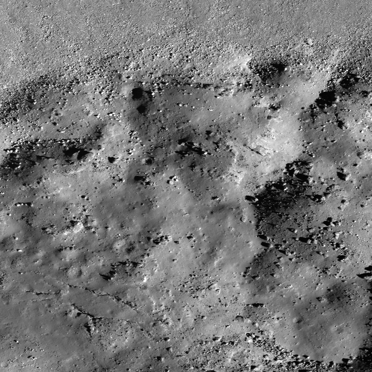
Deep interior of Laplace A crater, LROC Narrow Angle Camera (NAC) M129466485R, corrected resolution 0.80 m/pixel, field of view 960 meters; sunlight from southeast, incidence 66° (LRO orbit 4213, May 25, 2010) Full-sized LROC Featured Image HERE [NASA/GSFC/Arizona State University].

Hiroyuki Sato
LROC News System

During an impact event the kinetic energy of the meteorite is dissipated by compression, fragmentation, excavation and launching rock debris -- all resulting in an impact crater. The large amount of energy released also melts some of the target rock, and often times impact melt ponds form in the floor of the crater. Since the impact melt is liquid, it seeks an equi-potential level (surface is perpendicular to the gravity vector), thus it is flat and smooth as it freezes.

Today's Featured Image reveals the bottom of Laplace A crater, specifically the north edge of its impact melt pond. The upper side of this image corresponds to the lower part of crater wall, covered by lots of boulders. The surface of this melt pond consists of dozens of low mounds, possibly due to deformation of the pond surface after partial solidification. Perhaps rebound of the crater floor caused the level of molten material beneath the crust to rise and create small breakouts to the surface. There is also a cone shaped depression near these mounds. It may have formed as magma drained out from below?


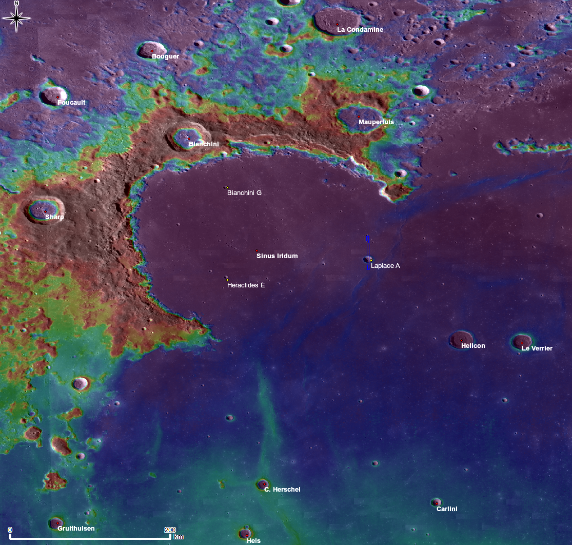
Inset from full-sized context map (HERE) shows the rich detail of the vicinity of Laplace A, the largest crater in the "mouth" of Sinus Iridium, south of Promontorium Laplace (upper right). LROC Wide Angle Camera (WAC) 100 meter/pixel monochrome global mosaic, overlayed by WAC color Digital Terrain Model (500 m/p). The blue long box over Laplace A corresponds to the footprint of the right-hand frame of LROC NAC M129466485 from which the LROC Featured Image above was derived [NASA/GSFC/Arizona State University].

Explore lunar landslides by viewing the full NAC frame!

The topographic color was produced as a by-product of stereo analysis of the WAC global dataset. Producing the global Digital Elevation Model (DEM) is a big job being led by LROC team members at the German Aerospace Center (DLR; English version) in Berlin.

Related Featured Images:
Impact melt features in Tycho crater's floor
The Floor of Tycho - Constellation ROI
Central Peak of Rutherfurd
More Impact Melt!


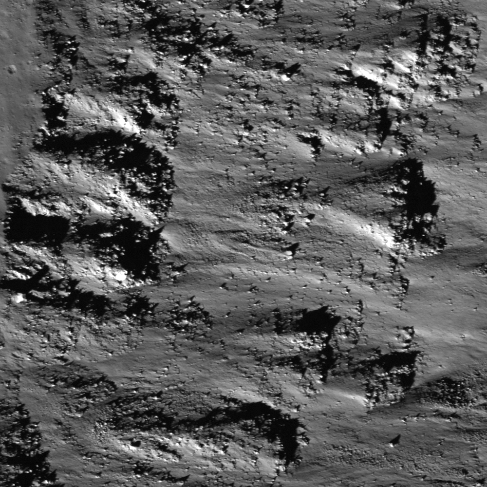
General location of the LROC Featured Image, February 24, 2011, within the wider context of the larger width of LROC NAC frame M129466485R [NASA/GSFC/Arizona State University].


It's unfair, really, to seemingly disparage this amazing view as being among the "middle range" of available resolutions in the current harvest from international lunar robotic missions. A 3D view of Laplace A as viewed at or near perilune during a high-priority survey of Sinus Iridium, (possible landing site for China's first lunar lander) from China's second lunar orbiter Chang'E-2, released last October 28, 2010. A larger version of the image is available HERE [CNSA/CLEP].

From LROC WAC Sample Album
Inset from uncorrected LROC WAC frame M120026575ME showing Laplace A, swept up during LRO orbit 2822 from an altitude of 36.36 km; resolution 50.92 meters/pixel, February 5, 2010. [NASA/GSFC/Arizona State University].