
 |
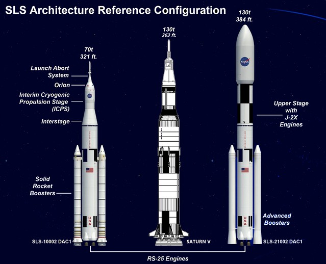
| All trussed up, with nowhere to go? NASA's Space Launch System (SLS) heavy-lift launcher compared with the Saturn V used to send Apollo to the Moon, forty years ago. |
Anthony Young
The Space Review
For the first time in nearly half a century, the United States will, in a matter of a few years, have the launch capability to send crewed spacecraft to the Moon. The launch vehicle that could make that possible is the Space Launch System (SLS). However, while the Moon was once a goal of exploration under the Vision for Space Exploration and Project Constellation, much further destinations are currently under consideration by NASA.
There have been several incisive articles in The Space Review against the SLS, primarily against the cost of its development and projected operation. Even the former deputy administrator of NASA, Lori Garver, has now publicly come out against the SLS, stating the launch vehicle design embraces decades-old propulsion technology (which it does) and that America can do better.
For better or worse, the heavy lift launch vehicle in America’s future will be the SLS. There is, as yet, no funded mandate—that is, program—to send crews to a near Earth asteroid, and the cost of mounting a crewed mission to Mars would give the Congressional Budget Office fits. Funding for such programs are for future congressional hearings to debate.
Under NASA’s website heading “Human Spaceflight Missions” is the subheading “Future Exploration Plans” with the following items: Asteroid Redirect Initiative, Commercial Space, Orion Crew Vehicle, and Space Launch System. Only the first item is a mission: the remaining three are not. You will not find a definitive mission goal for the SLS, only nebulous statements about taking astronauts deeper into space than ever before.
NASA also has an impressive science website. The tabs to go to specific pages regarding the space agency’s primary scientific thrust. They are (bypassing the Big Questions tab) Earth, Heliophysics, Planets, Astrophysics, Missions, Technology, and Science News. Conspicuously absent is a tab for the Moon. It is only under the Heliophysics tab one finds information related to lunar scientific exploration, in the form of a 2007 report titled “Heliophysics Science and the Moon: Potential Solar and Space Physics Science for Lunar Exploration.”
However, prior to this heliophysics-centric publication, the National Research Council (NRC) published “The Scientific Context for Exploration of the Moon”. The interim report was published in 2006 and the final report was released in 2007. It laid out the scientific rationale for the resumption of exploration of the Moon. There have, in fact, been many such strategy documents published over the decades since the end of Apollo by NASA, the NRC, and other organizations supportive of America’s return to the Moon.
It is clear, judging from the above-mentioned websites and documents, the current emphasis for scientific exploration is focused on the Sun, the Earth, and the planets, with seemingly cursory attention to the Moon. However, with the development of the SLS, the Moon may yet come back into favor.
The Space Review
For the first time in nearly half a century, the United States will, in a matter of a few years, have the launch capability to send crewed spacecraft to the Moon. The launch vehicle that could make that possible is the Space Launch System (SLS). However, while the Moon was once a goal of exploration under the Vision for Space Exploration and Project Constellation, much further destinations are currently under consideration by NASA.
There have been several incisive articles in The Space Review against the SLS, primarily against the cost of its development and projected operation. Even the former deputy administrator of NASA, Lori Garver, has now publicly come out against the SLS, stating the launch vehicle design embraces decades-old propulsion technology (which it does) and that America can do better.
For better or worse, the heavy lift launch vehicle in America’s future will be the SLS. There is, as yet, no funded mandate—that is, program—to send crews to a near Earth asteroid, and the cost of mounting a crewed mission to Mars would give the Congressional Budget Office fits. Funding for such programs are for future congressional hearings to debate.
Under NASA’s website heading “Human Spaceflight Missions” is the subheading “Future Exploration Plans” with the following items: Asteroid Redirect Initiative, Commercial Space, Orion Crew Vehicle, and Space Launch System. Only the first item is a mission: the remaining three are not. You will not find a definitive mission goal for the SLS, only nebulous statements about taking astronauts deeper into space than ever before.
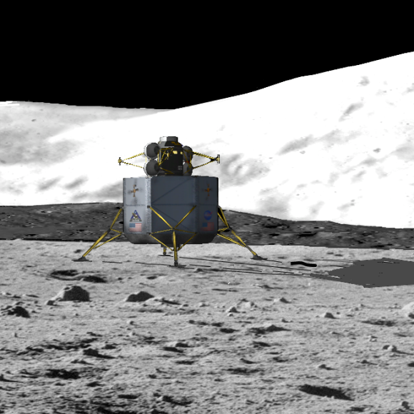 |
| The Constellation Altair lunar lander (as conceived in 2010) After the scrubbing of the Constellation program, the only vehicle still missing from it renamed replacements was a manned landing vehicle, along with plans for "extended human activity on the Moon." |
However, prior to this heliophysics-centric publication, the National Research Council (NRC) published “The Scientific Context for Exploration of the Moon”. The interim report was published in 2006 and the final report was released in 2007. It laid out the scientific rationale for the resumption of exploration of the Moon. There have, in fact, been many such strategy documents published over the decades since the end of Apollo by NASA, the NRC, and other organizations supportive of America’s return to the Moon.
It is clear, judging from the above-mentioned websites and documents, the current emphasis for scientific exploration is focused on the Sun, the Earth, and the planets, with seemingly cursory attention to the Moon. However, with the development of the SLS, the Moon may yet come back into favor.
Read the full article at The Space Review, HERE.


