Showing posts with label North Ray crater. Show all posts

Tuesday, June 19, 2012

Astronaut's eye view of the Apollo 16 landing site

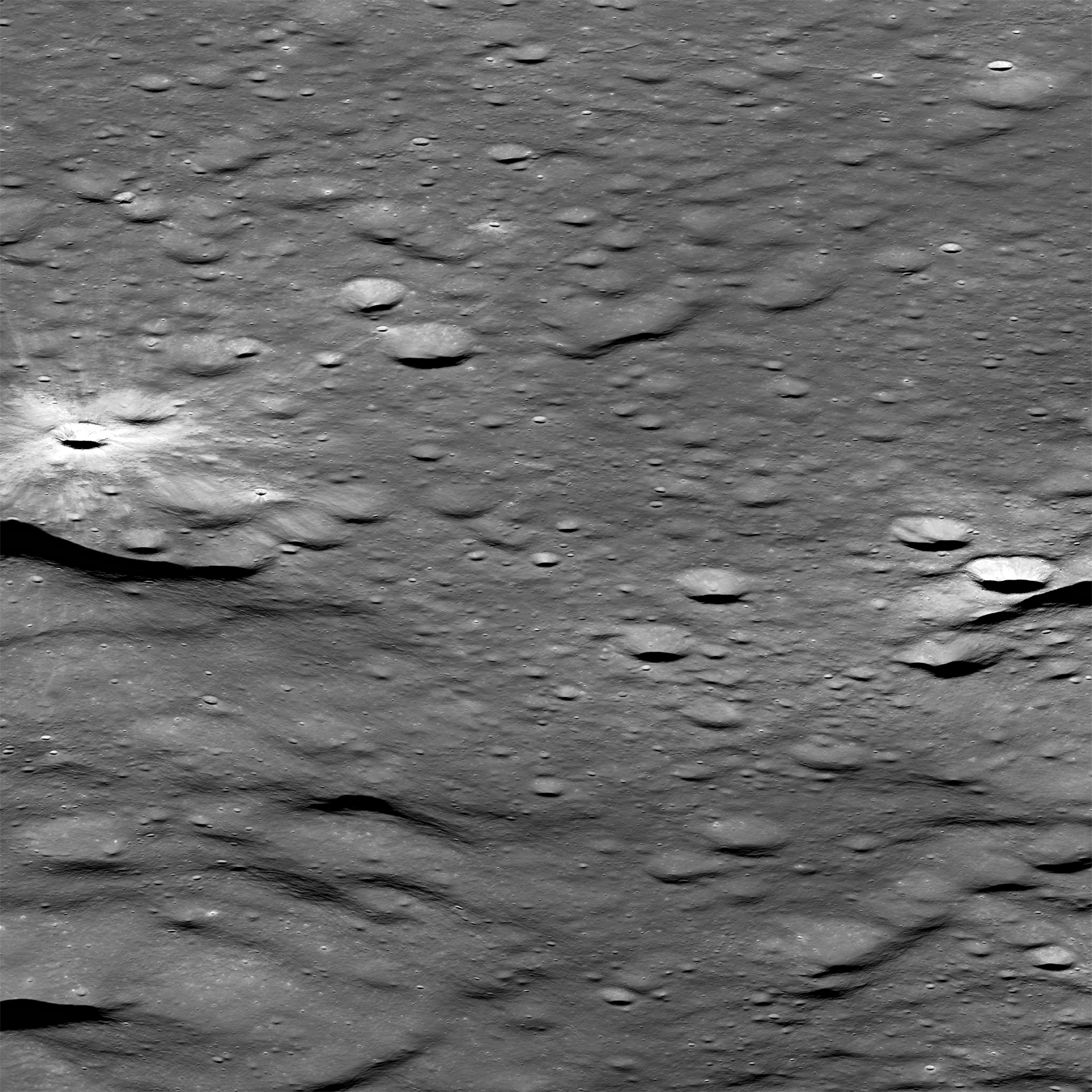
Oblique LROC Narrow Angle Camera (NAC) image of the Apollo 16 landing site, viewed from east to west.  Brighter South Ray crater is center left and North Ray crater center right, and the distance between the two landmark crater centers is 10.5 km. LROC NAC montage M192817484LR, LRO orbit 13442, May 28, 2012. View the 1600 x 1600 full-size 4 meter resolution LROC Featured Image HERE [NASA/GSFC/Arizona State University].
Mark Robinson
Principal Investigator
Lunar Reconnaissance Orbiter Camera
Arizona State University

On May 28 LRO was slewed 59° to the west, from an altitude of 92 km (57 miles) and captured a dramatic view of the Apollo 16 landing site.

During the Apollo 16 mission Ken Mattingly passed over the site several times at an altitude of 120 km (75 miles).  If you imagine yourself in the Command Module, then this view is close to what you would have seen.

The lighting is nearly identical to that of when the Lunar Module Orion set down on the Moon.

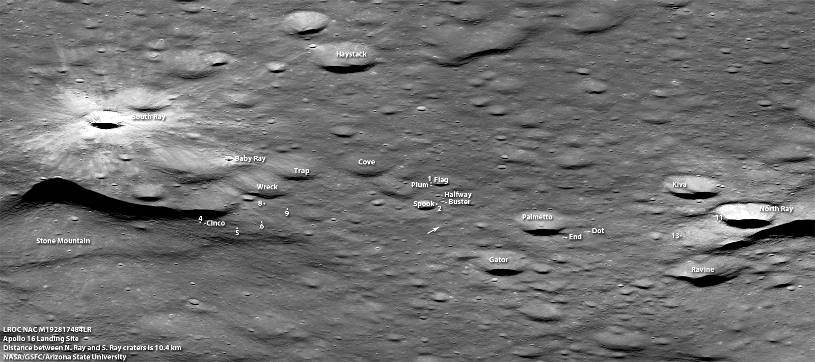
Subsampled subimage centered on Apollo 16 site, key craters and astronaut sampling stations are labeled (arrow shows location of lunar module descent stage and lunar rover), field of view 11 km across. View the 1600 px, full-size annotated image HERE [NASA/GSFC/Arizona State University]
On the second day of surface activities John Young and Charlie Duke headed south to sample material from Stone mountain and ejecta from South Ray crater. They headed south and turned east climbing up the flank of Stone Mountain. Imagine the view that Young and Duke had from Cinco crater (Station 4)! From their vantage point some 300 meters above the LM, the astronauts could see all the way from South Ray crater to North Ray crater.

Full resolution details from the Apollo 16 oblique image. Upper left: Lunar Module descent stage above and to the left of the forever parked Lunar Rover (arrows). Upper right: House Rock on the rim of North Ray crater. Lower left: Baby Ray crater. Lower Right: Shadow Rock (arrow). Each view is 530 meters wide and 1240 meters deep [NASA/GSFC/Arizona State University].
Full resolution field of view from a LROC Wide Angle Camera (WAC) monochrome (604nm) montage, swept up from a mere 38.27 kilometers, in orbit 11299, December 3, 2011; 52.3 meters resolution. Like the Featured Image, the illumination from the east, at a 69.57° angle of incidence, is similar to the lighting during the Apollo 16 expedition in April 1972 [NASA/GSFC/Arizona State University].
With the annotated version you can easily retrace the routes followed by Young and Duke as they spent three days exploring this highland landing site. Read a detailed reconstruction of the astronaut activities through the Apollo Lunar Surface Journal. 

What did they find at House Rock? Why was Shadow Rock an important science target? Is Baby Ray crater older or younger than South Ray crater? Then imagine yourself picking up where the Apollo astronauts left off over forty years ago!

When will we return to the Moon?

Dive into the full resolution oblique shot of the Apollo 16 site, HERE.

Retrace the astronaut traverses in an annotated version of oblique image, HERE.

Previous Apollo 16 LROC Featured Images
How Young is Young?


Tuesday, April 24, 2012

LROC: Orion, Up Close

40 years parked on the Cayley plain northwest of the Descartes formation.
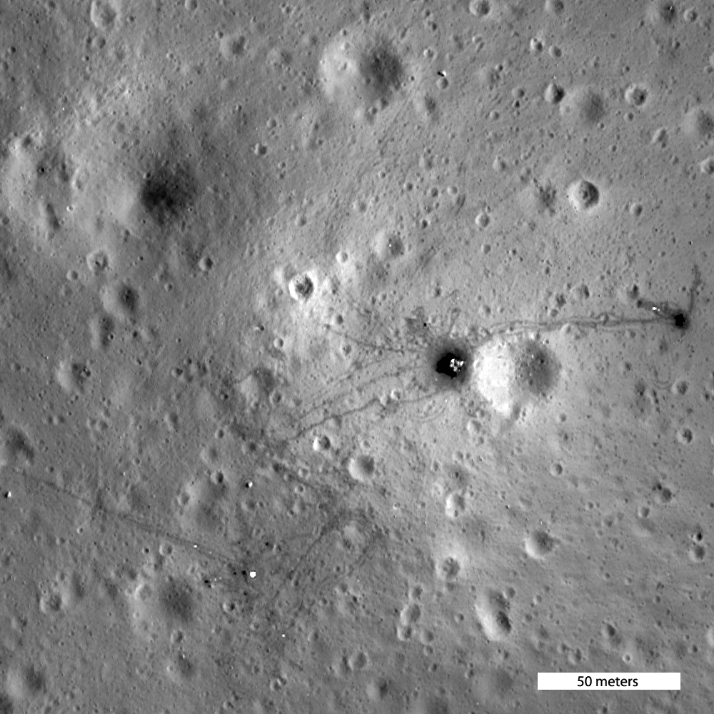
The second of two narrow periapsis orbital passes afforded the LROC team an opportunity to capture this astounding view of the Apollo 16 landing site, orbit 10950, November 6, 2011. LROC Narrow Angle Camera (NAC) mosaic M175179080; field of view above = 145 meters. See the 250 meter FOV in the LROC Featured Image, released on the 40th anniversary of the lift-off from the Moon of the Apollo 16 lunar module ascent stage Orion, April 22, 2012, HERE [NASA/GSFC/Arizona State University].

Mark Robinson
Principal Investigator
Lunar Reconnaissance Orbiter Camera
Arizona State University

The Apollo 16 Lunar Module Orion set down on the lunar surface 40 years ago (21 April 1972) after remaining in a holding pattern for six hours while technical issues with the Command Module Casper were resolved.

Here John Young and Charlie Duke undertook the first and only exploration of a highlands site; their main goal was to sample the enigmatic light plains deposits that geologists had interpreted as remnants of a large scale explosive volcanic eruption.

These proposed volcanic rocks were to be very different than the volcanic mare basalts sampled at previous sites (Apollo missions 11, 12, and 15).

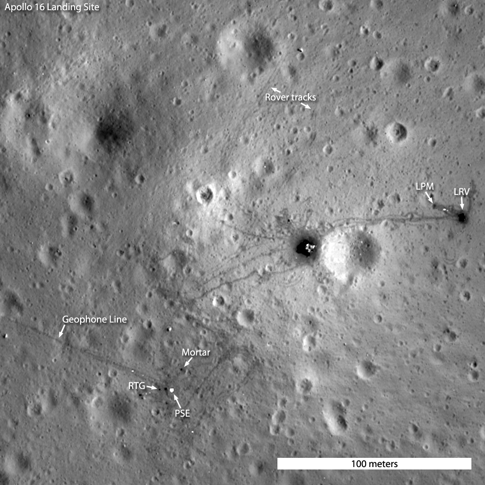
Annotated version of the LROC commemorative Featured Image of the Apollo 16 landing site, full image release 250 meters field of view (M175179080) HERE [NASA/GSFC/Arizona State University].
Once Young and Duke started looking at rocks near Orion, it became clear that there were no strange highland volcanic rocks. What they found were breccias, breccias, and more breccias. Why breccias, and how did they form? The Apollo 16 rocks were most similar to those collected by Apollo 14 astronauts Al Shepard and Ed Mitchell. As it turns out, the breccias formed as part of massive flows of ejecta from the Imbrium and Nectaris basin-forming events. Young and Duke were sampling crushed rocks that flowed hundreds of kilometers from their source!

Enlargement of Apollo 16 site, the Lunar Portable Magnetometer (LPM) is in the center of the dark spot below the annotation, the arrow shows Sun glint off an electronics cable, M175179080 [NASA/GSFC/Arizona State University].
Similar to the other Apollo missions, the Apollo 16 crew set up science instruments to measure varied aspects of the Moon and its environment. Most science instruments were part of the Apollo Lunar Surface Experiments Package, or ALSEP. The Apollo 16 crew also carried with them on their geology traverses the Lunar Portable Magnetometer (LPM) that measured variations in the strength of the Moon's weak magnetic field. Some of the ALSEPs (Apollo missions 12, 15, 16) carried a stationary Lunar Surface Magnetometer (LSM) that provided a point measurement for the landing site as a whole.

On April 22, 1972, minutes before the end of their third and final EVA, John Young took this photograph from his vantage over the lunar rover, parked for the final time so it's color television camera, controlled from Houston, could capture the ascent stage lift off. The LPM is just outside the full-size picture (AS16-116-18716) to the right, and the ALSEP site is in the distance on the left. [NASA]. 
Still image from the televised feed, after nearly 21 hours out on the lunar surface, at Mission Elapsed Time (MET) 175 hours, 31 minutes, 49 seconds, Young and Duke lift off in the Orion ascent stage, headed for rendezvous with Tom Mattingly awaiting them in the Command Module, and home [NASA/Apollo 16 Lunar Surface Journal]. 
The LSMs showed that from site-to-site the magnetic field varied by about a factor of fifty, from a low of 6 gammas (Apollo 15) to a high of 313 gammas (Apollo 16). From the LPM station-to-station measurements within the Apollo 16 traverses, the magnetic low was 121 gammas and high the high was 313 gammas; a factor of nearly three over a distance of 7 km.

The Apollo 16 Lunar Portable Magnetometer in its final configuration beside the parked rover. Note lunar sample rock 60335 is  temporarily perched on the magnetometer for calibration purposes. AS16-116-18721 [NASA].
The magnetometer on Lunar Prospector (1998-99) mapped
what may be the most intense crustal magnetism on the Moon
80 kilometers south of the Apollo 16 landing site, associated
with the bright albedo north of ancient Descartes crater
[Richmond, et al., (2003)].

After setting up the LPM, a final experiment was performed by measuring the magnetic field before and while a small rock was perched on the experiment. This experiment returned two important results: a) the local rocks had a remnant magnetic field so weak that the LPM could not detect it, and b) that the LPM was still working as before launch. These results came from the fact that the astronauts brought the sample (60335) back to Earth, and it was measured by an identical LPM as well as well as even more sensitive instruments.

What did these varied magnetic readings tell us about the Moon? The Moon's magnetic field comes from crustal and mantle materials, has no dipole signature, and is very weak. 

This is a magnetic field very different from the dipole field generated in the Earth's core. Right now scientists do not understand the origin of the lunar magnetic field or its variations. Perhaps the signature of an early, but now extinct, dipole field was captured in ancient lunar rocks as they cooled from a magma ocean. 

Perhaps basin-forming impacts induced local fields in the crust. These Apollo area measurements do tell us that the interior of the Moon is heterogeneous and complicated: the Moon is not a simple body. The two GRAIL spacecraft, Ebb and Flow, that are now in orbit about the Moon will provide gravity measurements that geophysicists will use to deepen our understanding of the lunar interior; the Apollo era magnetic readings will be part of that unfolding story.

Find the LPM and the rest of the ALSEP hardware in the full NAC image, HERE.

Previous LROC Apollo 16 Featured Images:
Apollo 16, Footsteps Under High Sun
How Young is Young?
Apollo 16 First Look
Apollo 16 North Ray crater

Young put the Orion ascent stage into a slow roll so Tom Mattingly could photograph the buckled skin of the spacecraft first noticed after the lunar module was retrieved from the SIVB after trans-lunar injection. The damage was made much worse by the force of its lift-off from the Moon. Back in lunar orbit, the distinctive craters Messier and Messier A can be seen at right. AS16-122-19535 [NASA/JSC].
Previous Low Altitude LROC Image Releases:
Apollo 11
Apollo 12
Apollo 14
Apollo 15
Apollo 17, Shorty crater

A fanciful edit of AS16-107-17435, showing how the Orion descent stage may look forty years after the brief, but productive expedition of Apollo 16.