Showing posts with label Phil Stooke. Show all posts

Sunday, October 12, 2014

New evidence for young lunar volcanism

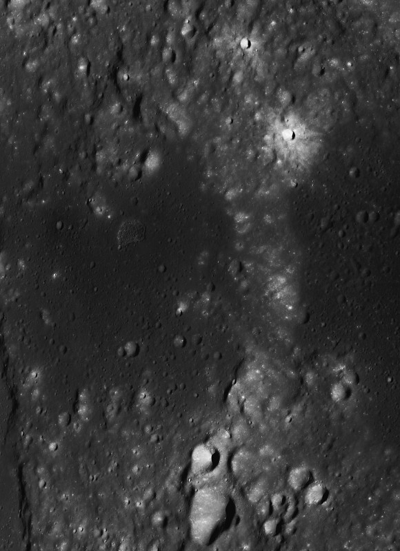
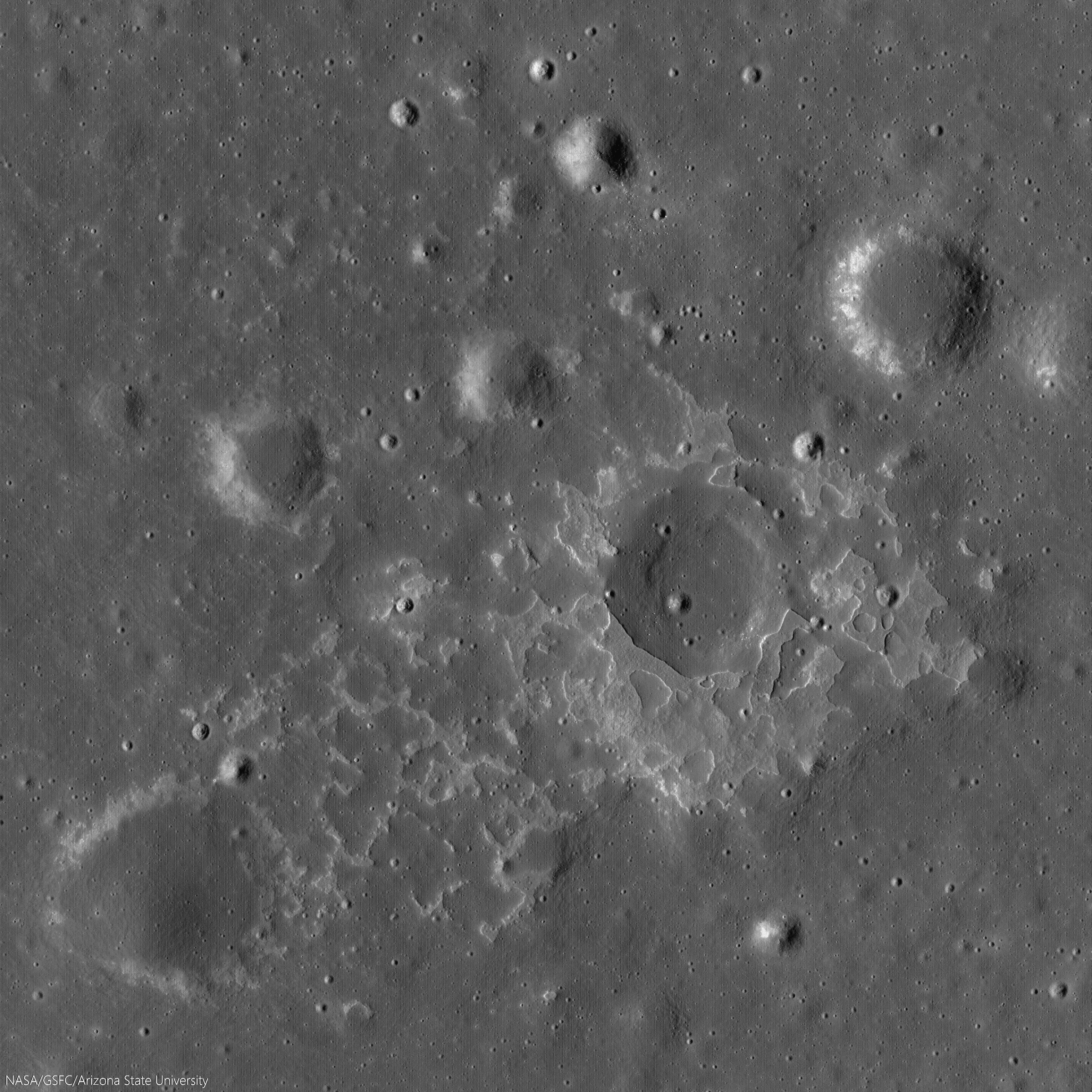
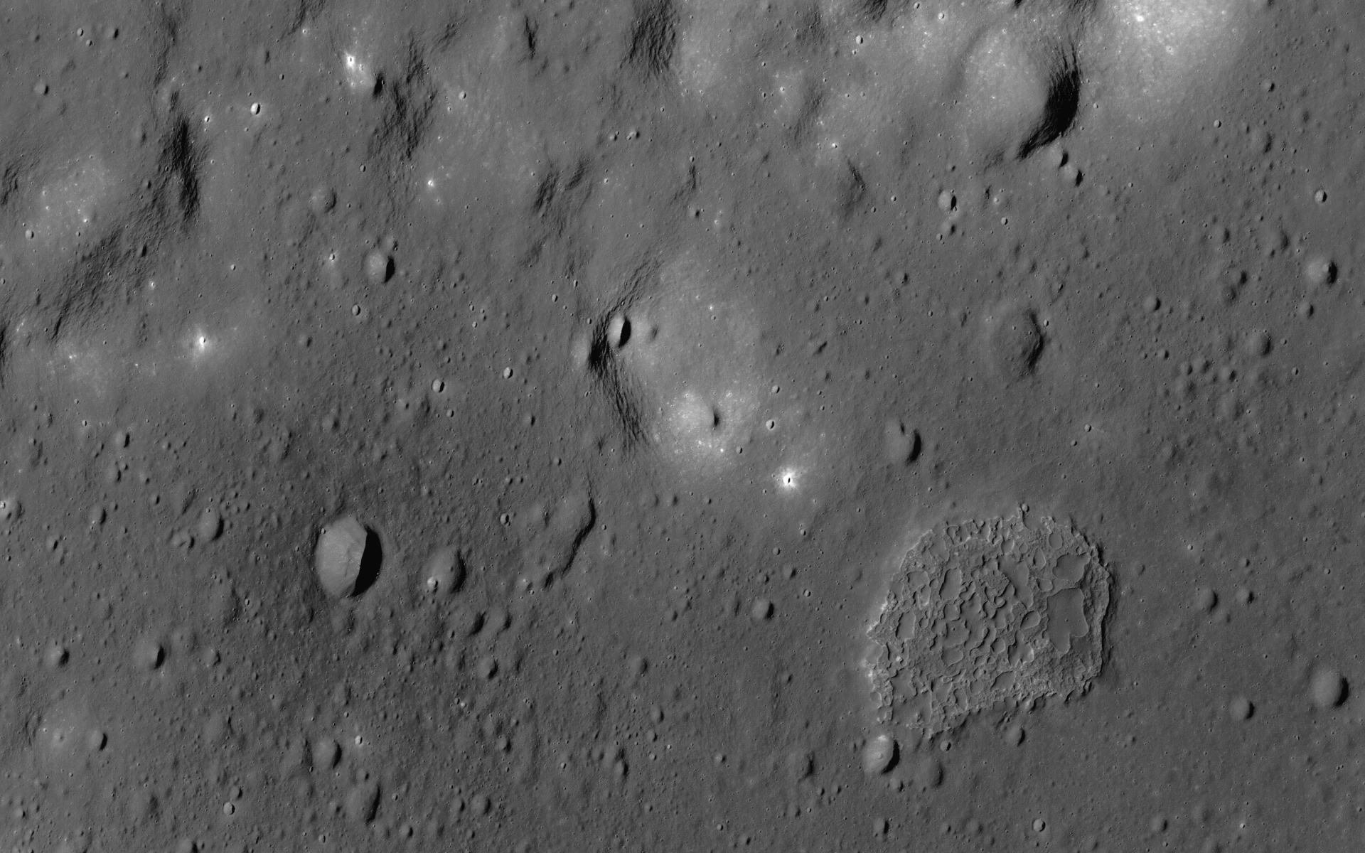
One of many newly-discovered young volcanic deposits on the Moon (4.330°N, 33.750°E), this example is near the crater Maskelyne, in south central Mare Tranquillitatis. Illustration from from "New evidence for young lunar volcanism," Mark Robinson, Oct. 12, 2014. LROC NAC observation M1123340138R, LRO orbit 17730, May 16, 2013; slew 3° from orbital nadir, incidence 66.55° resolution 1.04 meters from 102.5 km over 4.26°N, 33.97°E [NASA/GSFC/Arizona State University].
Mark Robinson
Principal Investigator
Lunar Reconnaissance Orbiter Camera (LROC)
Arizona State University

Many young volcanic deposits were recently identified in LROC NAC images. Their sharp nature and general lack of superposed impact craters greater than 20 meters in diameter indicate these deposits probably formed in the last 100 million years, perhaps even more recently than 50 million years ago. An amazing result!

A new paper, (Evidence for basaltic volcanism on the Moon within the past 100 million years, Nature Geoscience 7, 787-791; 2014) presents 70 topographic anomalies, informally called Irregular Mare Patches, or IMPs, most of these occurrences were previously undocumented. The IMPs are thought to be remnants of small basaltic eruptions that formed significantly after the commonly accepted end of lunar volcanism (1 to 1.5 billion years ago).
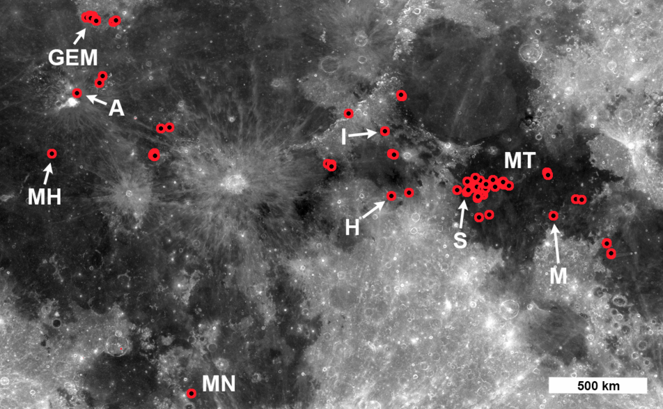
Locations of IMPs. Red circles indicate either a single IMP greater than 100 meters in diameter, or a cluster of smaller IMPs. The area extends from 28.0° N to 40.6° N latitude and 58.0 ° E to 50.3° E longitude, LROC WAC 643nm mosaic. IMP labels: Aristarchus (A), Gruithuisen E-M region (GEM), Hyginus (H), Ina (I), Mare Nubium (MN),  Mare Tranquillitatis (MT), Marius Hills (MH), Maskelyne (M), Sosigenes (S) [NASA/GSFC/Arizona State University].
Pursuing a Decades-old Puzzle

The best-known IMP, called Ina (or Ina-D), was originally spotted in Apollo 15 orbital photography, and was unlike anything else previously discovered on the lunar surface. Beginning with Apollo era investigations, Ina was interpreted as a collapsed caldera at the summit of a low-shield volcano. Previous interpretations of impact crater densities within and around Ina suggested that this enigmatic landform was much younger than the surrounding mare basalt unit in Lacus Felicitatis (Lake of Happiness).

Not only does the NAC provide excellent resolution, but after 5 years of operation has covered well over 75% of the surface. This combination led to the discovery of many new IMPs in locations across the nearside of the Moon. Ina is not simply a one-off oddity – but rather a signature of volcanic processes that actually occurred in multiple places across the nearside.
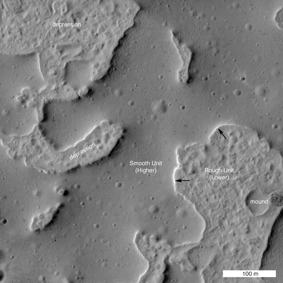
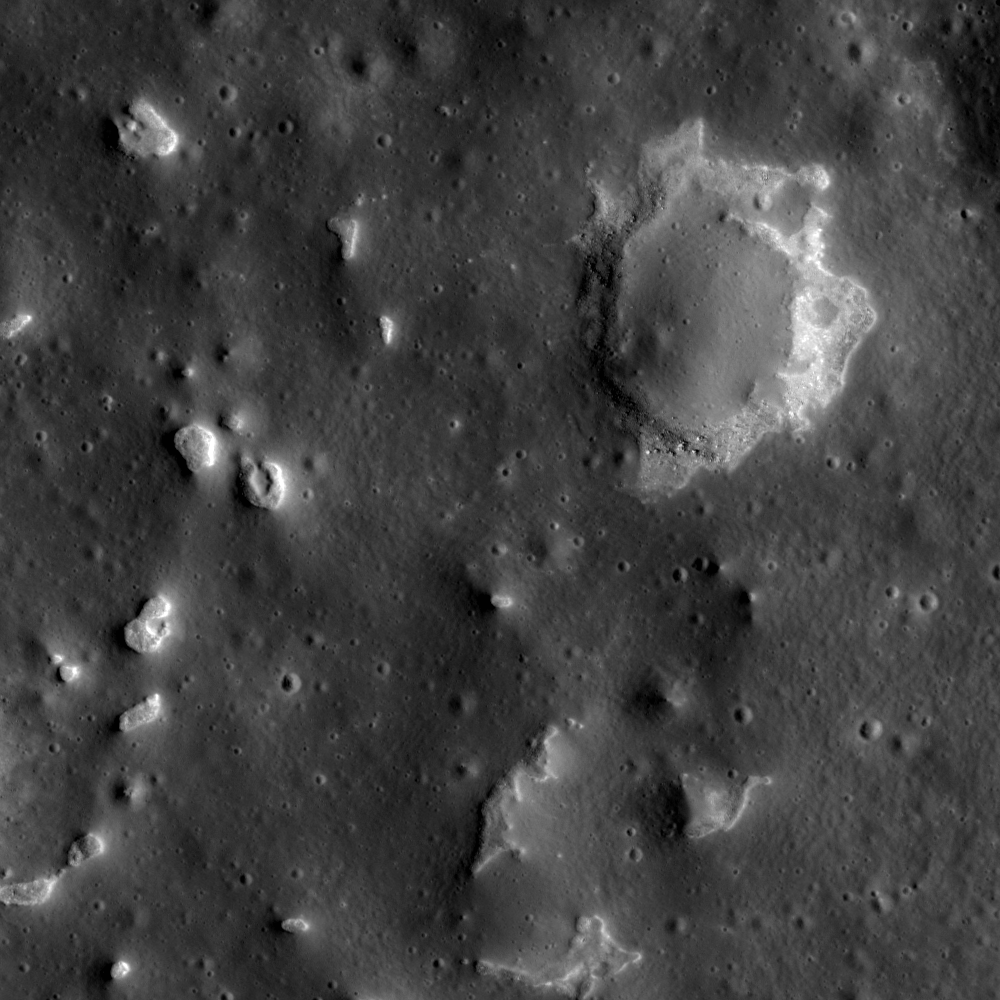
Close up of a small 464 meter wide section of the "IMP" familiarly known as Ina. This area is a great example of the difference between the rough and smooth units that make up the new family of IMP structures. The smooth unit is composed of mounds over the rougher units. The Sun is from the East, the black arrows show a Sun-facing cliff of one of the mounds. LROC NAC M175246029LR, LRO orbit 10960, November 6, 2011; 45.6° incidence, resolution 44 cm from 24.54 km over 18.91°N, 4.76°E [NASA/GSFC/Arizona State University].
New Discoveries

All of the lunar landforms identified as IMPs exhibit two distinct morphologies: smooth deposits, which are sometimes connected to the surrounding mare basalt, and uneven deposits (rough-looking) which usually end abruptly at the steep edges of the smooth deposit; it is likely that the smooth materials are covering portions of the rough material.

To estimate the age of IMPs the LROC team measured the sizes and numbers of impact craters on the smooth deposit surfaces (geologists use the crater size-frequency distribution (CSFD) as a metric for estimating the age of a surface). The resulting crater distributions from the three largest irregular mare patches imply ages younger than 100 million years. Indeed, the new crater counts confirmed that Ina is very young, perhaps as young as 33 million years.
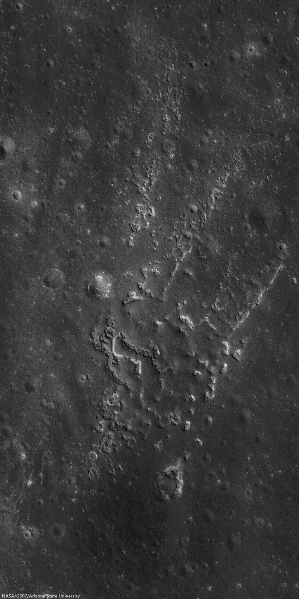
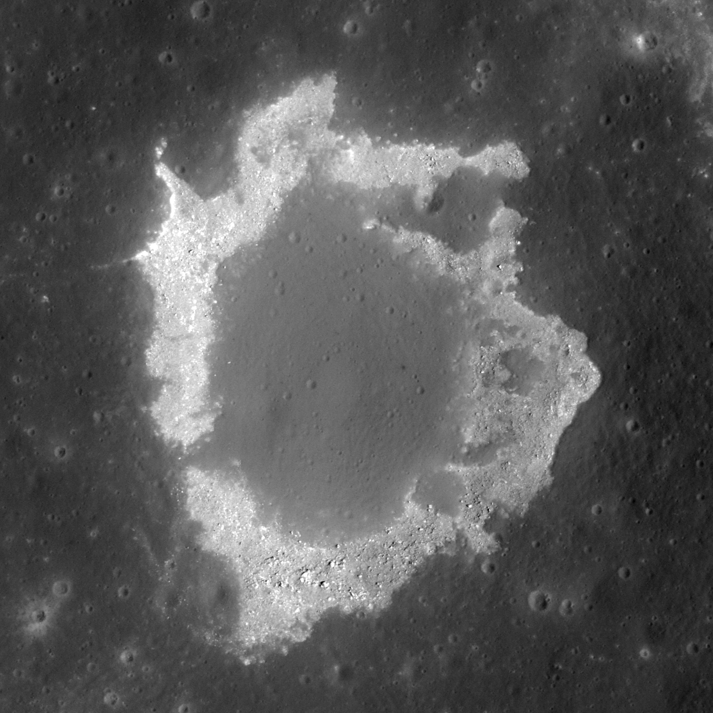
IMP north of Aristarchus crater (25.044°N, 313.233°E). Compelling evidence of the youth of this feature and its apparent origination from active processes within the Moon. As a matter of stratigraphy, the phenomena that caused this occurred after the formation of Aristarchus crater, a late Copernican age crater itself superposed on some of the Moon's youngest basaltic volcanic plains. 650 meter-wide field of view from LROC NAC observation M168509312R, LRO orbit 9967, August 20, 2011; incidence 42.67° at 40 cm resolution from 25.59 km over 24.7°N, 313.21°E [NASA/GSFC/Arizona State University].
Another key set of observations came from digital topographic maps derived from NAC stereo pairs that enabled quantitative relief and slope measurements of six larger IMPs. Measurements of the smooth deposit relief compared to the underlying uneven deposit revealed that the thickness of the smooth deposits (on average 8 meters, with a range of 2-20 meters) is consistent with the previously established thickness of lunar basalt flows.

Topographic slopes were measured at the edges of the smooth deposits where they contact the uneven deposits. Slopes that exceed the angle of repose, which is 30-35°, are evidence of relatively young surface features, because over time impacts and moonquakes will smooth over steep cliffs. Slopes on the edges of many of the smooth deposits exceed the angle of repose, providing more evidence for very young surfaces.

Changing the Way We Think About the Moon

Not only are the IMPs striking landscapes, they also tell us something very important about the thermal evolution of the Moon. The nearside has extensive mare basalt flows covering much of its surface, however we know from analysis of Apollo samples and crater counts that the bulk of lunar volcanism occurred from 3.9 to 3.1 billion years ago, and shut-off sometime around 1 billion years ago. However the IMPs seemed to have formed significantly after the canonical cessation of lunar mare basalt volcanism indicating the interior of the Moon is perhaps hotter than previously thought.
The contrast between the smooth and rough units stands out in this oblique view of Ina. The floor of the depression is about 50 m below the surrounding plains and is about 2 km wide. LRO oblique mosaic M1108203502LR, LRO orbit 15596, November 22, 2012; 52.18° slew from orbital nadir, resolution 3.75 meters from 127.29 km over 18.77°N, 11.64°E [NASA/GSFC/Arizona State University].
Full-width reduction of LRO oblique mosaic M1108203502LR, showing the interesting contextual features, some related, others likely not, subject of decades of speculation [NASA/GSFC/Arizona State University].
The new study of IMPs extends our knowledge of the extent of these fascinating deposits as well as their young age. What does it all mean? The young, small-volume extrusions of mare basalt imply a thermal history of the Moon where volcanism did not end abruptly, but rather decreased gradually over time (and may not be done!). With these newly discovered young volcanic features, scientists must consider that the Moon has a bit more heat in it that previously thought, an important new constraint for future models of the Moon's thermal evolution. Perhaps the abundance of radioactive elements (which provide heat as they decay) is higher -- important knowledge when figuring out how the Moon formed and evolved over time.

A provocative side note to the new thermal constraints — perhaps the Apollo heat flow measurements were spot on? Astronauts buried thermometers in the regolith during the Apollo 15 and 17 missions. The temperatures recorded were a bit higher than models predicted. At the time, scientists proposed that perhaps the two landing sites were in areas with higher heat flow than the average Moon, or perhaps there was an instrumental effect. The discovery of IMPs and their young age is certainly consistent with the higher temperatures measured by the Apollo crews.

Apollo 15 cmdr. Dave Scott working at the west Heat Flow hole (with St. George crater in the background). The drill is sitting on the ground next to the hole. Increased understanding of IMP phenomena increases the likelihood readings taken using the Apollo Heat Flow Experiments (HFE) during the Apollo 15 and 17 surface expeditions were not, afterall, anomalous. Apollo 15 EVA-2 AS15-92-12408 [NASA/JSC].
The IMPs are a fascinating part of the story of lunar volcanism over time, and now they must be considered high priority targets for future exploration. A sample return mission from one of these enigmatic deposits would tell us so much about the Moon as a whole. When did these lavas erupt? Is their chemistry different than the basalts returned by the Apollo astronauts? Is it likely that volcanic eruptions may occur at some point in the future?  A highly accurate age date for the IMPs would also serve as a much needed calibration point for the lunar cratering chronology; a crucial improvement not only for lunar studies but also for Mars and Mercury investigations.

Closer look at the IMP at Rimae Sosigenes - image follows below - Demonstrations Supplementary to "Evidence for basaltic volcanism on the Moon within the past 100 million years," Nature Geoscience 7, 787-791; 2014

Fig. 7 (top) Profile across a contact between smooth and uneven deposits, southeast feature. The relief of the smooth deposit is measured as the difference in elevation between the average flat surface of the smooth deposit (-1504 meters below global mean elevation; Sosigenes Graben NAC-DTM) and the base of the uneven deposit at the contact (-1514 meters). For this particular profile the smooth deposit is 10 meters thick. Note the lobate margin of the smooth deposit at the contact.

Fig. 5 (bottom) Craters on the smooth deposit of the Sosigenes IMP. The red circles are impact craters superposed on the smooth deposit of the Sosigenes IMP, delineated by the blue line; field of view roughly 5 km [NASA/GSFC/Arizona State University].
Spectacular oblique mosaic of the Sosigenes graben with it's large collapse pit, 2800 meters long and 300 meters deep, and floored with an IMP.  LROC NAC oblique observation M1108117962LR, LRO orbit 15584, November 21, 2012; 70.37° incidence, spacecraft and camera slew 55° resolution 2.5 meters from 114.87 km over 8.63°N, 24.9°E [NASA/GSFC/Arizona State University].
View full-window: Spectacular oblique NAC mosaic of the Sosignes graben with a large collapse pit (2800 meters wide, left-to-right; 300 meters deep) floored with an IMP.

Wider field of view from a spectacular oblique LROC NAC mosaic M152750200LR, LRO orbit 15584, November 21, 2012; 70.37° incidence, spacecraft and camera slew 55° resolution 2.5 meters from 114.87 km over 8.63°N, 24.9°E [NASA/GSFC/Arizona State University].
Inspect a variety IMPs using the LROC Quickmap: Cauchy-5, Nubium, GEM-30, Aristarchus North

Related Posts:
Inside Rima Hyginus (June 12, 2012)
Ina of the Meniscus Hollows (March 21, 2012)
Spectral properties of Ina (February 7, 2011)

Thursday, March 28, 2013

New Views of the Hollows of Rimae Sosigenes

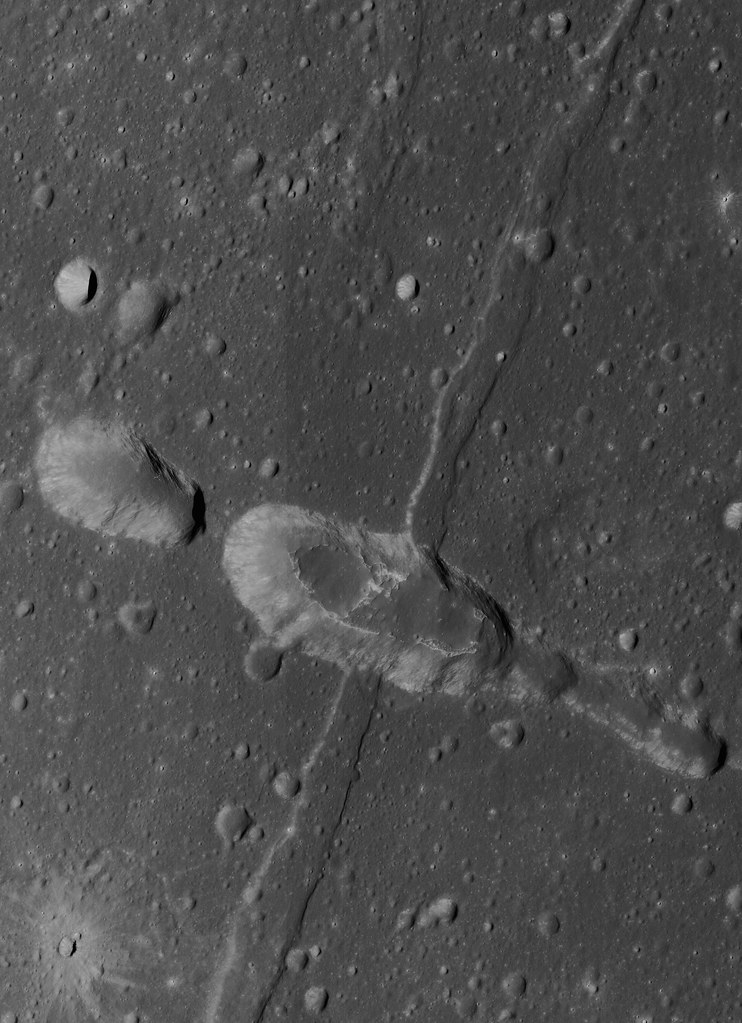
The Rimae Sosigenes region of northwest Mare Tranquillitatis, from a mosaic of newly released LROC Narrow Angle Camera (NAC) oblique (slew -55°) observations M1108117962LR captured in orbit 15584, November 12, 2012. The field of view is roughly 43 km from west to east (left to right) and scaled up considerably from an original 2.5 meter resolution, imaged from 146 km distance (114.87 km over 8.63°N, 24.9°E, angle of incidence 70.37°).   The largest crater above, Sosigenes A at lower left, is 11.3 km in diameter [NASA/GSFC/Arizona State University].
Joel Raupe
Lunar Pioneer

Running behind this holiday week, we're still busy digging through the latest, 13th batch of Lunar Reconnaissance Orbiter (LRO) data uplinked to the Planetary Data System (PDS) last week. The latest 90 day batch covers September 15 - December 15, 2012, and we're still hopscotching through it like a bee in a springtime garden.

But I wanted to take a moment to talk about hollows. The subject came up at the just-completed 44th Lunar and Planetary Science Conference, last week, in formal discussions about hollows on Mars and Mercury, and that fact reminded me it's been almost exactly a year since the fascinating topic of "meniscus hollows" on the Moon was discussed here.

A new LROC NAC observation of the Rimae Sosigenes area, captured last November, stood out among the few newly-released side-glance, or "oblique," NAC footprints in the latest LROC PDS batch, providing a new perspective on lunar hollows that did not come up in the conversation last year.

Phil Stooke of Western Ontario University collected an excellent inventory of these apparent remnants of gaseous blow-outs and presented it to the 43rd LPSC, last year. He's come up with the designation 'meniscus hollows," as fine description as may be. Among those in his catalog is "No. 8," on the "floor of a depression." 

The new oblique LROC NAC observation assembled at the head of this post shows us how deep that depression really is. Like a necklace encircling the floor of that depression (which resembles a vent, as seen elsewhere on the Moon) where it joins the wall.

A closer look at what was once thought to be a 'chain of craterlets,' a minor catena, slicing perpendicularly through one of a system of parallel north to south rilles - likely faults, that run from Maclear to Sosigenes A. Closer examination in more recent surveys by the LROC Narrow Angle Camera seem to show this structure to be a vent, perhaps related to the faulting. The above is medium resolution sample from  LROC NAC  M1108117962LR [NASA/GSFC/Arizona State University].
Elsewhere we've seen these hollows as hints of relatively recent geological activity, on ancient plains or on small extrusive domes - yet here we seem to see hollows placed in context with a visible complexity of formations with which they may be related. Perhaps some of the other hollows, like those situated alone on the Tranquillitatis plains south of Ross crater and east of Sosigenes, north of Arago and its domes, are all related to conditions under the surface that will turn out at least as complex. 

We don't know enough about Mare Tranquillitatis. It's not clearly an impact basin, like Imbrium and neighboring Serenitatis. It should be interesting to eventually examine the finer detail of these formations in the deeper granularity of the GRAIL mission data.

At Sosigenes faults run south to north parallel with the northwest edge of the mare. Classified as linear rilles, a kilometer or more wide, one is bisected perpendicularly by an 18 km long "gash," hinting at the collapse or shifting under the surface. It is probably immensely old, though at some point the floor of the depression may have been intruded upon from below, perhaps by gases venting at what may have been a weak zone, where the steep 380 meter walls of the depression meet the floor.

In depressed zones east and west of the central "depression of interest," the contact zone joining wall and floor has been blurred by mass wasting. Perhaps in the central depression, however, the distinction was made by material being blown out around the central floor. If so, it's not readily apparent around the outer edge of the formation (which is not the same as saying it isn't there.) Where did it go?

This 580 by 800 pixel sample of the full resolution mosaic (LROC NAC M1108117962LR) shows the 380 meter depths of the elongated formation is punctuated by 'meniscus hollows' very similar to others found just to the east, at the surface of Mare Tranquillitatis south of Ross crater, and more famously at the Ina structure, much further west. Perhaps they most resemble 'hollows' on the floor of the central depression of Rima Hyginus. Found here at the contact zone between the structure's floor and walls, the primary surface seems characterized by a low crater count. Are these hollows points where gases have explosively uncovered the structure's original floor?  [NASA/GSFC/Arizona State University].
 Closer still, in the full-resolution close-up above, something stands out, much as it does at that most famous of the 'meniscus hollows,' Ina. You can make your own comparisons with another new LROC NAC oblique mosaic detailed further below.

In short, the material covering the central depression's floor at its interior, away from the encircling hollows, doesn't appear to share the saturation cratering superpositioned upon it that is more characteristic of the surrounding plain. In fact, like the beaded "frozen liquid' appearance of the material at Ina, it looks relatively new.

A look more or less straight down (and at much higher resolution) at the eastern interior of the 380 meter deep central depression, at its walls together with a small part of the surrounding Rimae Sosigenes plain. Under higher illumination angles the depths of the topography defies our intuition. It doesn't look as deep as it in the oblique view further above, illustrating once again how relief seems to disappear on the Moon in the absence of shadows. From earlier LROC NAC observation M152750200LR, orbit 7645, February 19, 2011; resampled from 0.47 cm per pixel resolution  - angle of incidence 35° - from 39.56 km [NASA/GSFC/Arizona State University].
And an even closer look at one of the hollows along the contact between floor and the steep walls of the central depression at Rimae Sosigenes. Small boulders - apparently - shed from the wall  (and a slope of collapsed talus is piled at right (easier to see in the oblique view above). This field of view, 335 meters wide, comes from LROC NAC observation M177508146LE, LRO orbit 11295, December 2, 2011; angle of incidence 69.92° (slew -14.8°) resolution 0.48 cm per pixel from 37.86 km [NASA/GSFC/Arizona State University].
Optical maturity is no help here, hinting that the newest material is either more than a billion years old or does not result from the kind of kinetic energies released by cratering. In the image above, at bottom center, runs another contact line between the slope of "older" debris from collapsed walls at bottom right and the "newer" material "beaded" at the depression's center.

Is there a difference in the crater count? The material on the slope at bottom right seems darker, but that is likely an illusion from shadow and the elephant skin on nearly every lunar sloped terrain. It hardly counts as a control sample for counting craters and their size and erosion, etc., but no obvious difference in ages stands out between the two zones - nor are there any boulders or trails on either patch of ground. Those seem almost exclusive to the interior of the "blown out" hollows.

Perhaps the best large scale comparison with the meniscus hollows of the Sosigenes depressions is the endlessly compelling Ina formation of Lacus Felicitatis. And that's as good a segue as any to another newly-released LROC NAC oblique observation of that much studied and barely understood feature just below.

A fresh LROC NAC oblique view the Ina formation and its surroundings, a challenge for telescopes on Earth. A closer look at this mosaic's rendition of Ina's distinctive "D" is shown immediately below. Note the apparent rising cone of Mount Agnes, to Ina's northwest. This mosaic is assembled from LROC NAC M1108203502LR, exposing a field of view also roughly 43 km across, with both spacecraft and camera slewed -53°), looking west from 127.29 km over 18.77°N, 11.64°E, Sulpicius Gallus and southern Mare Serenitatis were directly below LRO, outside this side-looking view [NASA/GSFC/Arizona State University].
Perhaps it's a toss-up whether Ina or the hollows on the floor of the central depression of Rima Hyginus more closely resemble the hollows at Rimae Sosigenes. Perhaps the latter is something in-between. 

The view of Ina at an oblique angle, above and below, captured more than 140 km away from the LROC cameras, is not our most detailed look at that formation. Some unscaled examples of the very closest views of Ina surfaced with the LROC PDS release in December 2011. There doesn't seem to be much in the way of a depression resulting from the forces that created Ina, though the beaded remnants or surfacing seems to closely resemble the floor of the Rimae Sosigenes depression.

A new angle on the Ina (3 km across, 18.65°N, 5.3°E) from the immediately preceding mosaic sampled at its full 2.6 meter per pixel resolution [NASA/GSFC/Arizona State University].
Over the next decade or so, when researchers have time to weave together data collected by LROC, Mini-RF and from the GRAIL twins, a better picture of these 'meniscus hollows' will likely emerge. In the end, the formations themselves may turn out to be the surface manifestation of something deeper that we can hardly imagine today.

Related Posts:
Inside Rima Hyginus (June 12, 2012)
Whale of a Hollow (March 20, 2012)
Ina of the Meniscus Hollows (March 21, 2012)
The closest of lunar close-ups (December 16, 2011)
It's a gas, man (October 8, 2011)
Spectral Properties of Ina (February 7, 2011)

Tuesday, June 12, 2012

LROC: Inside Rima Hyginus

Collapse features within Hyginus Crater. 1240 meter-wide field of view from LROC Narrow Angle Camera (NAC) observation M104476560L, LRO orbit 556, August 9, 2009; resolution 1.24 meters from 122.77 kilometers. View the LROC Featured Image, released June 12, 2012 HERE [NASA/GSFC/Arizona State Univeristy].
Sarah Braden
LROC News System

Most craters posted to the LROC Featured Image page are impact craters, however, Hyginus Crater (located at 7.75°N, 6.27°E, in Sinus Medii) is a volcanic crater known as a caldera. Two main pieces of evidence suggest that Hyginus Crater formed through volcanic processes. First, Hyginus lacks a raised rim typical of impact craters. Second, the rim of Hyginus is irregular (not circular), which is typical for volcanic craters caused by collapse. Also, if you look closely with the LROC NAC, the interior of Hyginus has a number of small irregular depressions which are most likely collapse features, indicating a volcanic origin for Hyginus. These irregular depressions are in the Featured Image, distinguished by rough, high reflectance material around their edges.

Eight meter per pixel resolution view from LROC QuickMap shows the "meniscus hollows" features in context with the eastern interior of Hyginus [NASA/GSFC/Arizona State University].
The entire Hyginus region, shown in the LROC context image below, is a complex piece of lunar real estate. Not only do you have the volcanic crater Hyginus, but also Rima Hyginus, a linear rille, more volcanic collapse craters aligned with the linear rille, and a pyroclastic deposit around the crater Hyginus. How do all the geologic features relate to one another? The Hyginus region is so amazing that it was a candidate landing site for the canceled Apollo 19 mission. Had events turned out differently, we might know much more about the pyroclastic materials and the Hyginus caldera. Continue reading below for a summary of the scientific theory of how the Hyginus region formed.
An almost oblique view (spacecraft and camera slewed 19.57° east from nadir), LROC WAC view from 42.29 kilometers over an area west of Rima Hyginus. The caldera, particularly its east walls, can be seen here in some relief, without the high angle of incidence seen in the next image. LROC WAC observation M165814883C (604nm), LRO orbit 9570, July 20, 2011; native resolution 62.94 meters [NASA/GSFC/Arizona State University].
In a recent paper, scientists proposed a model of formation for Hyginus crater and Rima Hyginus. First, a body of magma from the mantle rose vertically through the lunar crust. The magma stopped rising near the surface and spread out laterally. This introduction of new material beneath the surface caused stress on the crust, which resulted in faulting. Eventually, gasses from the magmatic material still underneath the surface built up and increased the gas pressure, further increasing the stress on the crust.

LROC Wide Angle Camera (WAC) monochrome (689nm) observation of the Hyginus region. The yellow arrow marks the location of the collapse feature, the meniscus hollow, within Hyginus caldera seen at high resolution in the LROC Featured Image and the white arrow designates a small dome feature brought to attention by Maurice Collins. LROC WAC M117447052ME, orbit 2442, January 6, 2010; incidence angle 81.75° and a 62.6 meter resolution from 41.63 kilometers [NASA/GSFC/Arizona State University].
This stress eventually caused graben to open along the faults, and the same release of stress initiated an eruption, including pyroclastic materials. After the eruption of magmatic material an empty cavity beneath the surface was left behind. This cavity collapsed, creating Hyginus crater. The collapse craters along the linear rille also formed in a similar way.
LROC NAC image M126887222L gives another look at the largest collapse feature in the main image. This image field of view is 487 meters wide (588 meters in the LROC Featured Image release), and has a lower illumination incidence angle, which emphasizes albedo differences over the kind of relief visible in the LROC WAC image immediately above. LRO orbit 3833, April 26, 2010; incidence angle 28.28° with a resolution of 0.48 meters from 40.55 kilometers [NASA/GSFC/Arizona State University].
Explore more of the Hyginus caldera in the full LROC NAC, HERE.

Related Posts:
LPOD: Another Ina?
It's a gas, man
Brayley G
Sinuous Chain of Depressions
It's the Moon's Fault

You can read more about the Hyginus region in the Icarus paper, "An igneous origin for Rima Hyginus and Hyginus crater on the Moon."

The central and western Hyginus and Rima Hyginus region and points immediately north and beyond under mid-morning illumination, as seen from around 100 kilometers over the south , a forward-looking HDTV still captured by Japan's lunar orbiter SELENE-1 (Kaguya) in 2008 [JAXA/NHK/SELENE].

Wednesday, March 21, 2012

Ina of the Meniscus Hollows


Joel Raupe
Lunar Pioneer


Before my daughter left for college I tried to pass along a little advice Kurt Vonnegut once tried to impress upon me. I paraphrase: "warn your little Grade A students whom they shall inevitably meet on campus, no matter how gifted they may be. His name is Wolfgang Amadeus Mozart."
Such was the case yesterday only a few hours after posting "Whale of a hollow," which became an excuse to post a perspective shot of an extrusion dome on the geologically interesting southwestern edge of Mare Serenitatis.

The hollows perched on this isolated, but otherwise typical, mare extrusion dome resemble similar features discovered early in the Messenger survey of Mercury. We had a lot of images left over after a thorough study of this one site on the Moon from five months ago. And after simply stumbling on the "whale" structure, while we were examining a newly-released LROC Narrow Angle Camera (NAC) frame showing the Ranger 6 impact, we jumped on an excuse to discuss the Aratus-Serenitatis dome in that context; with the Ina structure and its distant cousin that also happens to resemble a cave dweller's rendition of a whale, or perhaps something one might see from the air flying over the plains of Nazca.

One of the better images of the Aratus-Serenitatis extrusion dome (24.77°N, 7.98°E), before LRO, is this 1971 Mapping Camera view (AS15-M-0410) from the Apollo 15 Service Module, 104 kilometers overhead. For a 21st century look at this dome, and in relief, an animated image demonstrating changes in the landscape during the long lunar day can be seen HERE [NASA/GSFC/Arizona State University].
Which brings us to "Mozart," who manifested almost immediately, first in the form of Phil Stooke, of Western Ontario University, a selenographer well-known for startlingly accurate maps of the Apollo landing sites before these were photographed for the first time in four decades from LRO. He also shares our interest in using the new and deep reservoir of LROC imagery to document the artifacts of human activity on the Moon, and he Emailed us after presenting a fairly comprehensive paper on the topic of lunar "meniscular hollows" at the 43rd Lunar and Planetary Science Conference underway in The Woodlands, Texas. Stooke gently recommended his paper, presented that very evening,
LUNAR MENISCUS HOLLOWS. P. J. Stooke, Department of Geography and Centre for Planetary Science and Exploration, University of Western Ontario, London, Ontario, Canada; 43rd Lunar and Planetary Science Conference (2012), #1011.
My first impression was how ridiculous the context view shown in yesterday's post appeared, one showing the location in Mare Tranquillitatis of the "whale" structure in its "serendipitous" relation to a nearby crater created by the 1964 impact of Ranger 6. That part of the floor of western Tranquillitatis, around the Ross and Arago crater and dome groupings, is crowded with these out-gas-formed "hollows." It will require some revision, to say the least. 

Figure 1. from LUNAR MENISCUS HOLLOWS, P.J. Stooke, U. Western Ontario, #1011, 43rd Lunar and Planetary Science Conference (2012), "Twenty Lunar Meniscus Hollows. Scales vary, image widths are between 300 and 1000 m, approximately." View a full-sized version of the plate HERE [Phil Stooke].
Of course, that's what's being said of all the lunar maps and textbooks these days, and that's a good thing.

The second question is an unfair one. Are there any such "blow-outs" on the Moon's farside? Even the Lunar Reconnaissance Orbiter Camera hasn't photographed the entire Moon in high-resolution, but it's close.

While examining his impressive catalog of 27 nearside hollows, as we prepared to show it off beyond the narrow confines required by the conference, YouTube videographer jayem4646 , who's work has appeared in these pages before, followed up on Stooke's note by calling attention to perhaps the best attempt so far to digest what's been so recently learned about the Ina structure, the "D caldera," and most famous of the lunar meniscus hollows.

It's seen in the embedded video above, way ahead of the Scientific Visualization Studio (SVS) at Goddard, and definitely in their class. 

We missed attending the LPSC this year, but it's warmed more than one heart knowing someone attending that grand meeting found the website useful, or at least amusing!