Wednesday, June 30, 2010

Another look at Reiner Gamma


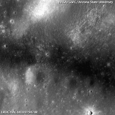
The heart of the Constellation Region of Interest in the Reiner Gamma swirl. Astronauts exploring this region will address longstanding questions about the origins of this distinctive natural feature. Image field is 510 meters across [NASA/GSFC/Arizona State University].

Bashar Rizk
LROC News System

First identified by early astronomers during the Renaissance, the Reiner Gamma formation has been a subject of intense scientific study for almost five decades and is one of the highest-priority targets for future human lunar exploration.

Reiner Gamma is one of the most distinctive natural features on the Moon. This striking, tadpole-shaped swirl has a significantly higher reflectance than the surrounding mare basalts.

-
LROC Wide-Angle Camera monochrome context image of the Reiner Gamma swirl. (Arrow indicates approximate location of the Narrow-Angle Camera detail above.) The field of view is approximately 80 km (M117874527ME) [NASA/GSFC/Arizona State University].

Several LROC Featured Images have shown spectacular new images of the swirls near Mare Ingenii which are similar to the swirls of Reiner Gamma. Reiner Gamma, however, is the "prototypical" lunar swirl.

A concept that comes up frequently in lunar science is "space weathering." This term is used to describe a suite of natural processes (including micrometeoroid impacts and exposure to solar wind) that can alter the spectral properties of lunar surface materials.

Since the reflectance of the lunar surface within the Reiner swirl is so different from the surrounding mare, some process may have altered the space weathering susceptibility of the swirl materials. There are several theories to account for the presence of the Reiner Gamma swirl. Results from previous lunar missions (including Lunar Prospector) have indicated that the swirl region has an elevated magnetic field, so it's possible that an event hundreds of millions of years ago modified the magnetic properties of the surface materials, deflecting the solar wind and changing how the reflectance is modified by space weathering.


The most familiar lunar swirl graces the western expanse of Oceanus Procellarum, as seen from Earth. The crater Reiner (right, center) is 31 km across. [Astronominsk, September 2007].

Some investigators have proposed that the coma of a comet - streaking in just above the surface - interacted with the lunar surface, changing the surface properties to the degree where the Reiner Gamma swirl could persist for millions of years.

However, based on the available data, we just don't know for sure! That's not a bad thing; if we knew all the answers to all of these interesting problems, we wouldn't ever need to explore! We will not know what caused the swirls of the Reiner Gamma formation until human explorers return to this region to do the fieldwork and collect the samples that will enable us to answer this fundamental scientific question.

Plan your own adventure to the enigmatic swirls of Reiner Gamma! Think about where you would go to answer these scientific questions!

For more information on LROC's observation campaign for the Constellation program regions of interest read this Lunar and Planetary Science Conference abstract, and visit the LRO Science Targeting Meeting website (look for the baseball card summary sheets for each site: part 1, part 2).


Magnetic field lines associated with Reiner Gamma at 35.5 km, as measured from Lunar Prospector (1998-1999), traced on Clementine (1994) 'natural color' mosaic. (Units are nT) - Varieties of Lunar Swirls, Blewett, Hughes, Hawke & Richmond, 38th Lunar and Planetary Science Conference (2007), Abstract #1232.

Local Topography and Reiner Gamma
May 22, 1010

Lunar Swirl Phenomena from LRO

May 17, 2010

Heart of Reiner Gamma
November 17, 2009

Saturday, June 26, 2010

LOLA: Goddard


NASA/GSFC June 25, 2010 - Goddard Crater is located along the Moons eastern limb (14.8 N, 89.0 E). LOLA data show the floor of the 90 km diameter crater to be relatively flat and smooth. The crater is named after pioneering rocket scientist Robert H. Goddard (1882-1945). Considered to be to be the father of modern rocketry, Goddard built the worlds first liquid-fueled rocket. Incidentally, the LOLA instrument was built at the one NASA Center named for Robert H. Goddard, Goddard Space Flight Center in Greenbelt, MD. The Lunar Reconnaissance Orbiter on which LOLA flies was also built at Goddard Space Flight Center.

+ View Image | + High Resolution


Lunar Orbiter IV swept up one of the better overhead images of Goddard, before the Apollo era. The best Apollo mapping images of the region, straddling the border between near side and far, just beyond Mare Crisium on line of sight from Earth, were taken almost too far south. After that, Albedo images of Goddard and Mare Marginis confirmed the presence of what is probably the most wide-spread field of swirl phenomena on the Moon. The swirls are interlaced with a complex lunar magnetic anomaly that is antipodal to Mare Orientale [NASA/JPL/LPI].


In the era of LRO, for the first time investigators are gathering their highest quality images of the Goddard crater and it's inundated interior. From Apollo 17, ejecta rays from Goddard A, to the northeast, mixed with the widespread albedo swirls, looked like cirrus clouds gently scudding over the larger crater. This Wide Angle Camera sampling, overlain low-resolution albedo photography from Clementine, has made it much easier to separate those rays from other surface features, like secondary crater chains, etc. [NASA/GSFC/Arizona State University].


Dr. Robert H. Goddard (1921), father of the liquid fueled rocket.

+ Learn more about Robert H. Goddard

"It is difficult to say what is impossible, for the dream of yesterday is the hope of today and the reality of tomorrow."

- Dr. Robert Hutchings Goddard

Friday, June 25, 2010

Who will win the Google Lunar X-Prize?


Nancy Atkinson
Universe Today

Twenty-one teams are hard at work trying to win the Google Lunar X PRIZE, a $30 million international competition to safely land a robot on the surface of the Moon. The GLXP folks released a video this week as an update on how the teams are progressing. The challenge is not only to land a robot on the Moon, but it also must complete a few tasks – and none of this is easy: travel at least 500 meters over the lunar surface, and send images and data back to Earth.

Although the challenge was announced in 2007 and the teams have been working on their respective rovers, no team is a clear-cut favorite in this competition. In fact, some reports say that no one is likely to actually succeed in the task and win the prize money.

But Will Pomerantz, Senior Director of Space Prizes at GLXP begs to differ and told Universe Today that having so many teams in the hunt for the prize makes the competition — and the excitement — even better.
Read the article, HERE.

Thursday, June 24, 2010

No way to run the space program

Mike Hollie
The Huntsville Times

President Obama's determination to overhaul the space program has become painfully clear to hundreds of households in Huntsville this week.

Some contractor employees working on the Constellation program have already been told to expect layoff notices and buyout offers, and others will probably join them this week and next. Up to 1,000 or so jobs are at stake at 21 local contractors employing 1,750 people on the Constellation program.

Nationwide, from 2,500 to 5,000 people working on Constellation will be dismissed during a tepid recovery from the nation's deepest recession in eight decades while space program supporters are trying to save their jobs.

Read the post, HERE.

Wednesday, June 23, 2010

LROC: Forked flow on the Far Side


Impact melt flow split into two distinct segments. The source crater is 2.5 km to the south in the Steno-Tikhomirov region of the northern Far Side highlands (ENE of Mare Moscoviense). The field of view is 900 meters. The LROC Narrow Angle Camera frame M112902715L was imaged in LRO orbit 1772, last November 15, from 55 km over 30.02°N, 160.99°E. The forked impact melt flow is one of numerous exciting geologic features found on the Far Side. [NASA/GSFC/Arizona State University].

B. Ray Hawke
LROC News System

Young, Copernican-aged lunar impact craters exhibit spectacular deposits of lava-like material produced by shock melting in and around the craters. These lunar impact melts are observed as thin, hard-rock veneers, flows, and ponds. Today's Featured Image highlights a spectacular example of a large impact melt flow that flowed from a young small highlands crater (~3.1 km in diameter). The distal portion of this curved impact melt flow splits into two separate flows (opening image) about 2.5 km from the crater rim. What caused this impact melt flow to fork?

Local topography most likely influenced the impact melt flow path. At the point where the two flows diverge, the main flow is 320 m wide. The northern flow segment extends 675 m beyond the point of divergence and is 200 m wide near its end. The northeastern segment extends for 550 m from the main flow and is 210 m wide near its end. Both flow segments exhibit numerous cracks along portions of their lengths.


This context image is a thumbnail of a larger mosaic of the central portion of two complementary NAC frames (M112902715L and R), showing the forked impact melt flow and source crater. Field width is 4.3 km, and illumination is from the east, with a spacecraft-target-solar incidence angle of 51.65° [NASA/GSFC/Arizona State University].

The impact melt deposits associated with this farside crater are unique for two reasons. First, the volume of melt present on the crater exterior is exceptionally large, especially when compared to the melt deposits observed on the crater floor. Second, the exterior melt deposits are found at large distances from the crater rim. Studies of impact melt deposits during the Apollo era indicated that craters in the ~3-4 km diameter size range exhibited only very small volumes of exterior melt concentrated near the rim crests. Observations of <5 km diameter craters using the LROC NAC images will greatly improve scientists' understanding of impressive impact melt flows such as this one!

Investigate the impact melt flows at other locations around this crater for yourself!


Inset from a larger notional wallpaper image showing the "view" overlooking the Far Side lunar highlands in the vicinity of the two loosely associated crater groups, Steno-Tikhomirov, east of Mare Moscoviense. The simultaneous Narrow Angle Camera frames overlay the southern end of LROC Wide Angle Camera frame M115264486CE, nested within the digital elevation model available to users of the Google Earth program (>v.5). The smooth, forked impact melt is visible on the north-northeast outside slope of the unnamed source crater, at bottom [NASA/GSFC/Arizona State University/USGS/JAXA/Google].


Thumbnail of a full-sized wallpaper mosaic, the "view" looking south-southwest over the Steno-Tikhomirov region of the far side lunar highlands, at middle latitudes north of the equator, east of Mare Moscoviense [NASA/GSFC/Arizona State University/USGS/JAXA/Google].

Uranium at the lunar surface spread thin


Relative brightness indicates the signature strength of Uranium on the lunar surface, mapped using the fast and slow neutron detection on-board Lunar Prospector (1998-1999). Even at low resolution the outline of Mare Imbrium and the Copernicus cluster standout. Like more familiar maps showing the more abundant radioactive element thorium, the areas in and around the enormous South Pole-Aitken Basin can be seen [NASA/LSI].


The well known "spike" in uranium prevalence surrounding Imbrium and most notably Copernicus and Fra Mauro is verified in this study of data gathered using Japan's lunar orbiter Kaguya (SELENE-1). The Imbrium signature is indicative of either the elemental make-up of the progenitor or of the lunar interior, or both. Its antipodes near on the far side overcame a low threshold of signal-to-noise ratio, but looks are deceiving. Data show the "spike" northwest of Copernicus, for example, demonstrates only relative abundance, amounting to only 2.1 ppm, according to this latest study. [JAXA/SELENE/N. Yamashita et al., Geophysical Research Letters].

Charles Q. Choi
Space.com

A new map of uranium on the moon has revealed the lunar surface to be a poor source of the radioactive stuff, but it could help solve mysteries as to how the moon formed.

This new moon uranium map dampens hopes of a nuclear power industry on the lunar surface, researchers said.

Proponents of lunar bases and future lunar colonies have long pointed to many of the moons minerals, along with water, as being useful to support such efforts.
Read far from the last word
on the subject
, HERE.

Tuesday, June 22, 2010

Target of Opportunity

It's a fresh impact and unusual, if natural. It clearly caught the attention of the LROC targeting team. A cluster of narrow-angle camera surveys of the area, near the center of Mare Crisium (17.05°N, 60.31°E), were released to the Planetary Data System this past March.

It appears to be the final resting place of an "artifact of human activity," perhaps one previously undetermined.

And yet... looks can be deceiving. In the contextual view of the image field below, is that a trail, associated with this fresh impact, connecting it with what appears to be a far older impact, just to the southeast? If the depressed terrain is not just a more likely coincidence, perhaps the more recent impact disturbed or dampened the surface and partially uncovered surface features buried below the immediate surface.


LROC Narrow Angle Camera frame M115916471LE, LRO orbit 2216, December 20, 2009; 44.87 km over 17.05°N, 60.36°E (phase angle = 81.7°, illumination from the east, southeast - right) [NASA/GSFC/Arizona State University].


By way of comparison, the inset above shows the feature as shown at only slightly more "Zoom" than the in the full image immediately prior from December (the larger frame zooms in on the feature still further in this Commissioning Phase image). The LROC team swept up the feature in Narrow Angle Camera frame M104118529LE, during orbit 506, August 5, 2009; 137.46 km over 16.74°N, 60.47°E (phase angle = 59.84°) [NASA/GSFC/Arizona State University].


And, yet Again, on September 1, 2009 during LRO orbit 836 (LROC NAC M106482789RE), spacecraft cameras were slewed 4 degrees from 145.32 km over 17.81°N, 60.43°E, apparently with the aim of capturing the feature in a Sun quite a bit higher in lunar the sky (phase angle = 30.16°).

A transition to a more highly illuminated moonscape was nearly complete, unveiling some finer features previously hidden in shadows even as others were washed out in the albedo of rougher terrain. The center of the impact is almost completely washed out in the higher sun, though the same conditions allow investigators to measure the wispy rays of ejecta spread away from the impact. [NASA/GSFC/Arizona State University].

Wetter Moon complicates lunar origins

"We are in the midst of a renaissance of lunar science."

Paul D. Spudis
The Once & Future Moon
Smithonian Air & Space

Is there water on the Moon?

We know now that the answer to that question is a resounding Yes! As information continues to emerge from a wide range of studies, it’s evident that we’ve just begun to understand the process of the creation, movement and history of water on the Moon and its prevalence.

A paper recently published in the Proceedings of the National Academy of Sciences describes lunar samples containing the calcium-phosphate mineral apatite. Using a sensitive technique, they detected water (in the form of its ion hydroxyl, -OH) within the crystal structure of this mineral. Moreover, these hydroxyl-bearing apatite grains are found in several different rocks from a variety of geological settings. This indicates that the presence of water in the lunar interior is not some fluke, but a general property of the Moon. So the story of water on the Moon advances.

Why did scientists believe for so long that the Moon was bone dry? Largely because the samples returned from the Apollo missions contained no obvious hydrous phases, such as mica or amphibole, common water-bearing minerals in terrestrial igneous rocks. In addition, the chemical composition of lunar samples indicated that they formed under very reducing conditions, indicating very low partial pressures of oxygen. Typically, water oxidizes metals in magma on Earth, creating minerals that contain ferric iron (Fe3+); the exclusive presence of ferrous (Fe2+) iron in lunar samples indicates that no water was present during their formation.

Finally, there is the extremely reducing nature of the current surface environment of the Moon, in which solar wind protons (hydrogen ions) continuously impinge upon the surface and reduce metal oxides in the soil. This hydrogen reduction creates “free” metallic iron (0Fe) and hydroxyl ions, most of which are lost to space through a variety of mechanisms. But at least some of these ions migrate to cooler regions of the Moon, the poles.

We now have found traces of water in volcanic glasses, mare basalts and an alkali highland rock. All these samples are very different types of material, formed from different parent materials at different places within the Moon at different times and under different conditions.

The rocks possess apatite grains that show evidence for the presence of water at the time of their formation. One reason that we are finding this water in lunar samples now is that the technology of laboratory instrumentation has vastly improved since lunar samples were first studied 40 years ago.

The ion microprobe used in the study by McCubbin and others resolved a spot size on a mineral grain about 8 microns (about 100th of a single millimeter) in diameter. Additionally, the composition of this spot was resolved with extremely high precision, measuring the presence of water at about 3 parts per million or better. We now have at our disposal a variety of brand new lunar samples in the form of meteorites – rocks that were blasted off the Moon during impact events. More than 130 individual lunar meteorites are now known; one of the samples in this new study is a piece of a lava flow (mare basalt), found as a meteorite from Northwestern Africa.

The results of the new discoveries indicate that water is (or at least was) present in the deep lunar interior. This water probably existed as gas as the pressures and temperatures within the Moon do not permit the existence of liquid water. The total amounts of water implied by this work are still very low; the bulk lunar water content is estimated to be between 0.064 to 21 parts per million, a low amount by almost any standard – except when compared to the previous estimate for the Moon, which was less than one part per billion of water. Thus, the new estimate suggests water contents inside the Moon that are several orders of magnitude higher than previously thought.

So what does all this mean? For models of lunar origin, some mechanism preserved primordial water inside the Moon immediately after it formed. It had been thought that if the Moon originated during a collision of a planet-sized object with the proto-Earth 4.5 billion years ago (the currently favored model), the high temperatures extant during such an event would “boil away” most, if not all, volatile substances. Indeed, the near absence of volatile substances in the Moon has long been cited as prima facie evidence for a high-energy environment of lunar formation, such as would be expected from a giant impact. It now appears that regardless of high temperatures prevalent during this time, some water was incorporated into the Moon. Does this make the giant impact model less likely? Perhaps. Clearly we do not fully understand the conditions created by such an event. Work continues on the problem of lunar origin with the handicap that a planetary-scale collision is something well beyond human experience or observation.

Some of this endogenous lunar water may have found its way into one of the permanently dark, extreme cold “traps” near the poles of the Moon. Thus, in addition to the water made on the Moon from solar wind reduction and deposited on its surface by the collision of water-bearing asteroids and comets, we must also consider the addition of water from the deep lunar interior.

Considering that our estimate of the abundance of internal lunar water is still very low, it is likely that the vast bulk of the water found at the poles is of external origin. Therefore, the possible finding of indigenous “Moon water” in the polar areas makes detailed study and examination of the poles even more attractive.

The Moon continually surprises us as she reluctantly (but always provocatively) reveals her secrets. In recent months, a wholly new and totally unexpected picture of the processes and history of our nearest planetary neighbor has emerged. We are in the midst of a renaissance of lunar science.

Friday, June 18, 2010

Congratulations LRO, One Year in Space

Congratulations to NASA, Goddard Space Flight Center, and all Lunar Reconnaissance Orbiter teams and team members, upon completing a very successful and historic First Year in Space!

LOLA's Malapert Region


NASA/GSFC - 6.18.2010 - Located near the lunar South Pole, the Malapert region (85.99 S, 357.07 E) is of interest as a potential location for lunar exploration. In addition to revealing the elevation of different points on the lunar surface, such as the topographically high Malapert Massif, LOLA data can also be used to classify surface roughness and to model how much sunlight different areas on the lunar surface receive for given amounts of time. With these models, scientists can find places that never receive sunlight, commonly referred to as permanently shadowed regions, as well as those that are constantly illuminated. LOLA data can also be used to determine how easily an area on the Moon could communicate with Earth by switching the "light source" in illumination models to "Earth." Areas with high "illumination" in this situation have better visibility from Earth (people on Earth can see them most often), and therefore have better communication pathways between the Earth and the Moon.


LOLA data have found the rim of Malapert Massif to have high illumination. Malapert Massif also has exceptional Earth visibility, and because of its excellent communication potential (and interesting science potential!), the Malapert region has been suggested as a site for future lunar exploration. + View Image | + High Resolution

Turned on it's head, for the convenience of the Earth-bound, the now-iconic HDTV Earthset frames imaged by Japan's first lunar orbiter Kaguya (SELENE-1), released in 2008 [JAXA/SELENE].

LROC: Test Wide Angle Camera Release


The Orientale basin is the youngest of the large lunar basins. The distinct outer ring is about 950 km from east-to-west, the full width of the LROC WAC mosaic is 1350 km [NASA/GSFC/University of Arizona].

Mark Robinson
Principal Investigator

The LROC team is producing preliminary large area mosaics with Wide Angle Camera (WAC) images now that enough data has been collected to derive inflight calibration coefficients and determine photometric corrections. The mosaic above is from images collected by the WAC in monochrome mode. When the sun is low on the horizon, color and reflectance variations are muted, so instead of imaging in the typical seven-color mode, image data from only one filter is read out. This gives a beautiful look at topography and morphology; later, when the sun is higher in the sky, the area is re-imaged in color, and the surface features can be correlated to their color signatures. Because the mosaic is preliminary, it still has some areas that appear black where image data was not included.

The mosaic is of the multi-ring basin Orientale, the youngest of the large lunar basins. Orientale is only partially flooded by later eruptions of mare basalt, unlike basins like Imbrium, so its internal structure is still visible. This view into the interior can help us learn more about basin formation and the mechanics of how basins develop their concentric rings. Orientale is the site of two Constellation regions of interest; one was the subject of a past featured image, the other is located near Kopff crater inside the basin. Kopff has unusual fractures in its floor (see NAC detailed view below), and the impact crater may have been modified by later volcanic activity, making it an exciting place to visit. Astronauts would also be able to sample the Maunder formation, thought to consist primarily of rocks that were completely melted by the heat generated during the impact.


A NAC view inside one of the fractures on the floor of Kopff crater, a 41 km crater within the Orientale basin and near the Orientale 2 Constellation Region of Interest. Image M122794259RE, scene width is 670 m [NASA/GSFC/Arizona State University].


The approximate location of the NAC detail above, in the range of the M122794259RE frame (yellow), is indicated with the small white square inside Kopff crater. The crater is easily visible on the right side of the central basin of Mare Orientale in the WAC Featured Image [NASA/GSFC/Arizona State University].

While LROC NAC images give unprecedented detailed views of the surface, WAC mosaics provide a synoptic view of the catastrophic power of large impact events, like the one that formed the Orientale basin. Explore the full-resolution NAC image of Kopff, and the full-resolution WAC mosaic of Orientale!

From Lunar Pioneer 3

Standing on the floor of Kopff, a glance over the NAC frame toward the crater rim, ~20 km away.


There is much to see in this medium-close up of the Wide Angle Camera mosaic of Mare Orientale, from the vent of the Orientale pyroclastic formation at center bottom to the complex fracturing and inner rings of the southwestern edge of the impact basin's central floor. The release of LROC WAC mosaics have been highly anticipated, filling gaps in our baseline understanding of the Moon's surface [NASA/GSFC/Arizona State University].

Thursday, June 17, 2010

Return to Moon, Schmitt says, important for protection of liberty and freedom

Dr. Harrison “Jack” Schmitt, lunar module pilot for Apollo 17 speaks at the Barter Theatre in Abingdon, Virginia, Wednesday evening, June 16, 2010 [Bristol Herald Courier].

In a speech to a packed Barter Theatre on Wednesday, one of the last men to step on the moon – one of just 12 who’ve had the opportunity in the history of human spaceflight – interspersed humor with a serious message: the need for America to steer its best and brightest toward the sciences and a return to the moon.

Schmitt was at the Barter as part of a week-long series of space-focused activities ahead of the Friday opening of “The Blue-Sky Boys,” a play about the creative process behind putting men on the moon.

“Not being there would have been like giving up the oceans 200 years ago,” Schmitt said of landing on the moon. “And it would not be good for this country and for the protection of liberty and freedom on this planet.”

Read the article HERE.

Wednesday, June 16, 2010

Depths of Mare Ingenii

Updated June 17, 2010 1702 UT

Impact craters are visible everywhere on the Moon, but pits are rare. This pit in Mare Ingenii (35.95°S, 166.06°E) is about 130 meters in diameter! Image width is 220 meters, illumination is from the upper right, NAC M128202846LE [NASA/GSFC/Arizona State University].

Lillian Ostrach
LROC News System

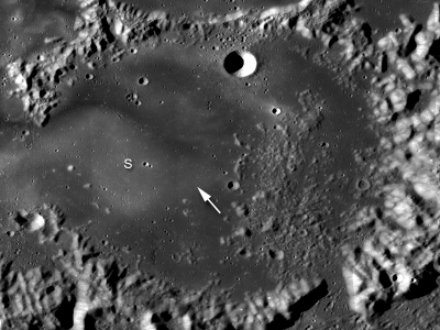
Mare Ingenii may be best known for its prominent lunar swirls, which are high albedo surface features associated with magnetic anomalies. However, lunar swirls are not the only unique geologic feature found in the farside "sea of cleverness". The high-resolution cameras aboard the Japanese SELENE/Kaguya spacecraft first discovered this irregularly-shaped hole, visible in the opening image at LROC's 0.55 m/pixel resolution. The boulders and debris resting on the floor of the pit are partially illuminated (left side of the pit, above image) and probably originated at the surface, falling through the pit opening during collapse.


Arrow indicates location of pit. "S" indicates one of the numerous lunar swirls located in this region. Portion of LROC WAC mosaic, 200 m/pixel resolution; image width is 160 km [NASA/GSFC/Arizona State University].

A pit in the Marius Hills region, previously discovered by the JAXA SELENE/Kaguya mission, is thought to be a skylight into a lava tube in the rille-riddled region. Similar to the Marius Hills pit, the pit in Mare Ingenii is probably the result of a partially collapsed lava tube. However, the numerous volcanic features of the Marius Hills (such as the prominent rilles and domes) are not found in Mare Ingenii - so how did this pit form? Future human exploration to this location would surely help scientists answer this question!

Peer into the depths of this exciting
LROC NAC frame
!

From Lunar Pioneer 3


As LRO approaches its first anniversary, perhaps the greatest accomplishment by the wide-ranging team operating the vehicle is the opportunity to relearn a lesson that continues to escape notice by many:

No understanding of Earth can be complete without a proper study of the Moon.

Above we see the sinkhole at Mare Ingenni (35.95°S, 166.06°E), one of three similar pits, holes or "caves" discovered on the Moon so far. It's not possible for us to improve on the LROC NAC M128202846LE frame, nor any other product produced by Dr. Marc Robinson and his team at Arizona State University. So we try, instead, to offer different perspectives. Hopefully this may inspire others to study the Moon also. Above, we trade a loss of resolution for a "closer" look at Ingenii Cave, and from a pilot's angle, putting a depth of field in the mind's eye. The obvious stratigraphy, just below the dusty surface, begs for a closer investigation. [NASA/GSFC/Arizona State University].

New surfaces near Lichtenberg Crater ROI

This close up image of the wall of Lichtenberg crater shows distinct layering of pre-impact mare deposits. LROC Narrow-Angle Camera frame M112040133L; scene is 530 m across, imaged November 5, 2009 in LRO Orbit 1645; altitude 47.72 km (phase angle - 59.63°) Full Sized LROC Featured Image [NASA/GSFC/Arizona State University].

Mike Zanetti

Lichtenberg crater is of Eratosthenian age, 20-km across and 1.2-km deep, located in western Oceanus Procellarum (31.8°N and 292.3°E). It is named after George C. Lichtenberg (1742-1799), a German professor of experimental physics, specializing in the study of static electricity.

Lichtenberg has an extensive ejecta blanket with highly reflective rays which extend to the North more than 100 kilometers from the crater rim. Within the detailed image shown above, distinct layering inside the crater wall can be seen. These layers are probably outcrops of the original surface lavas which were deposited before impact event.


Enhanced color Wide-Angle Camera view of Lichtenberg crater (~20 km in diameter). High reflectance rays of ejecta extend from the crater to the North (gray areas) while the rays in the south and east have been buried by basalts (dark blue areas). The 689, 566, and 415 nm filters are in red, green, and blue, respectively. LROC WAC image M122659235C [NASA/GSFC/Arizona State University].

Lichtenberg's high reflectance rays are caused by impact-related ejection of high albedo highland material from beneath the low albedo mare basalts that flooded the region before the crater formed. In the enhanced color wide angle camera (WAC) image above, the bright rays of ejecta can be seen extending away from the crater to the north. However, they are not visible to the south and east of the crater. This is because in this region, the ejecta blanket was later buried by mare basalt. The stratigraphic principle of superposition tells us that this basaltic flow must be younger than the Lichtenberg impact crater, and is thus one of the youngest volcanic deposits on the Moon! This young basalt flow is characterized by its dark, smooth, and homogeneous surface with a low crater frequency, compared to other areas around Lichtenberg crater.

This exciting region near the southeast rim of Lichtenberg is a Constellation Region of Interest.

Exploration of this ROI offers the opportunity to study one of the youngest surfaces on the Moon. Crater size-frequency distribution measurements suggest that Lichtenberg crater rays southeast of the rim are covered by basalts that are approximately 1.7 billion years old. However, this region has not yet been sampled directly during any lunar mission, so this age is only an estimate. Sending astronauts to the southeast rim of Lichtenberg will offer the opportunity to collect samples of these mare basalts and determine the age of this youngest lunar volcanism to better understand the geological evolution of the Moon.

Explore the Lichtenberg Crater Constellation Region of Interest yourself!


Looking east by northeast over the rim of Lichtenberg Crater shows the elevation differences and unusual morphology of the terrain excavated by this unique crater in the far northwestern Oceanus Procellarum. The LROC Featured Image is set within the Narrow-Angle Camera field from which it was taken, and its companion frame, both set upon the Wide-Angle Camera context shown above. 20 km- wide Lichtenberg, as a relatively recent formation with ejecta subsequently covered adds evidence to even more recent morphology. The elevations marked are at distinct points, Lichtenberg averages 500 meters less deep than the -4181 meter depth found at one location on it's floor [NASA/GSFC/Arizona State University].

From Lunar Pioneer 3

Tuesday, June 15, 2010

New Constellation program manager appointed

Marcia Smith
SpacePolicyOnline

NASA just announced that the new program manager of the Constellation program is Lawrence D. Thomas, who most recently was deputy program manager for Constellation at Marshall Space Flight Center. The new job is at Johnson Space Center (JSC).

Charles M. Stegemoeller was appointed as Constellation deputy program manager. He had been director of the program planning and control office for the Constellation program at JSC.

More HERE.

LOLA: Moscoviense


Mare Moscoviense (GSFC - LOLA Image of the Week, June 14, 2010) is one of the few large maria located on the far side of the Moon.

LOLA data reveal the lowest point inside Titov crater to be about 2.7 km below the lunar datum. In contrast, the highest point on the rim of the basin rests about 3 km above lunar datum.

The total relief for the basin surrounding Mare Moscoviense is 5.7km. Although there are just as many impact basins on the lunar far side as the near, the extensive lunar volcanism seen on the near side is lacking on the far side of the Moon [NASA/GSFC/LOLA].


The spectacular Moscoviense Terrain Camera image from 2008, returned by Japan's first lunar orbiter Kaguya (SELENE-1). The yellow arrow indicates the location of a new and distinct kind of lunar rock discovered from data returned by India's first lunar orbiter Chandrayaan-1. The story from April 12 can be read here [JAXA/SELENE].


Figure 2, LROC News System Featured Image, January 8, 2010. LROC Wide Angle Camera color (Red=689, Green=566, Blue=415 nm) mosaic, with the location of the proposed Constellation Region of Interest (ROI) indicated with arrow [NASA/GSFC/Arizona State University].


Looking east over the Moscoviense Constellation ROI, LROC WAC M103531211, overlaid with LROC Narrow-Angle Camera image M105887165, atop the improving resolution of the lunar far side elevation map available in Google Moon. The arrow on the WAC image released by LROC is not completely covered, left center [NASA/GSFC/Arizona State University].


Stepping back from the false-color data in the LOLA Image of the Week, at the top, "bright is equal to relative height" in this look at Moscoviense in the global-scale, low-resolution LOLA data available through the Planetary Data System. Titov is just visible, and unlike visible imagery of the area, the multi-ringed nature of this impact basin is clearly visible along with a strong indication that the original inner ring may have been partially inundated with intrusive molten material, probably from within the Moon after it's original formation The obliquity of the "impact-forming event," retained in its present 'rectangular' shape also appears to have been a part of the formation from the instant it formed [NASA/GSFC/LOLA].

Some other postings related to Moscoviense:

Far Side was volcanically active
until 2.5 billion years ago

June 13, 2009

Far Side borderland landing site
October 6, 2009
Mare Moscoviense Constellation Landing Site
January 8, 2010

New spinel-rich lunar rock type
April 12, 2010