Showing posts with label Astronominsk. Show all posts

Thursday, May 22, 2014

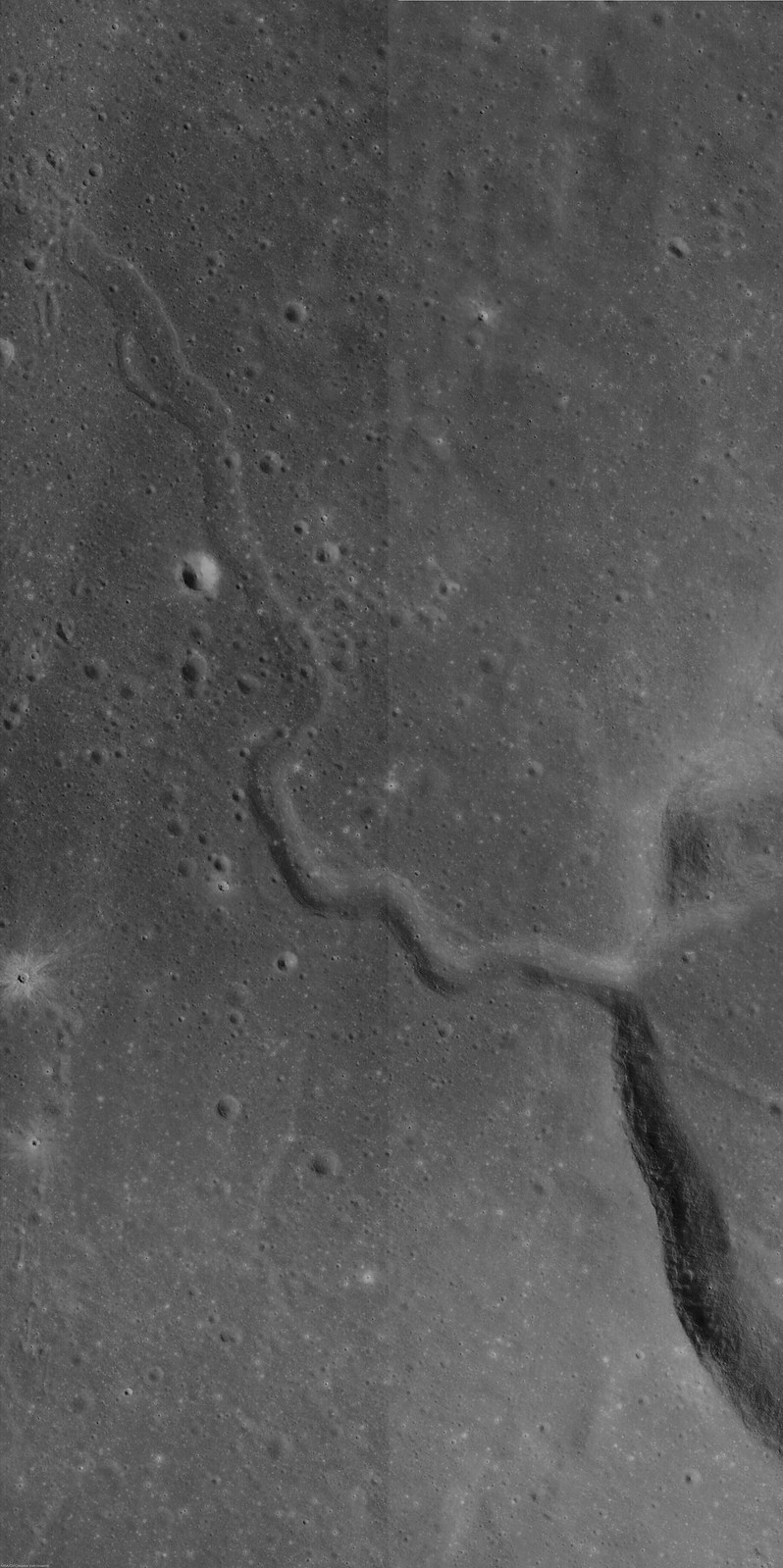
Kink in Rima Krieger

Rima Krieger winds its way through Oceanus Procellarum. Image width is ~ 3.5 km. Taken from LROC NAC observation M1152172510R, LRO orbit 21780, 50.29° incidence angle, resolution 1.35 meters, from 134.64 km over 29.19°N, 313.9°E [NASA/GSFC/Arizona State University].
H. Meyer
LROC News System

Rima Krieger is located in central eastern Oceanus Procellarum. "Rima", which means "fissure", refers to lunar rilles, a common feature on the lunar surface.

Rilles located in mare deposits can form by two mechanisms, channelized lava flow or lava tube collapse, often combined with tectonic stresses. They display three major morphologies: linear, arcuate, and sinuous.

Rima Krieger is a sinuous rille, meaning that its twists and turns resemble meandering rivers on Earth.  Sinuous rilles are thought to have formed as lava became channelized on top of a thick lava flow, as seen at Vallis Schröteri, or as lava flowed across the surface and carved into the substrate.

A roll through four modern orthographic perspectives of Krieger (with 10 km Van Bisbroeck crater superpositioned on its south rim) and the narrow pass through the crater's west wall, where Rima Krieger begins. The region is dominated by its proximity to young Aristarchus crater to the southwest. A 42 km field of view with data contributed by the Lunar Orbiter series, Clementine and LRO [NASA/GSFC/Arizona State University].
In the case of Rima Krieger, some of the meanders occur at nearly right angles, suggesting that the flow was controlled to some degree by underlying structure. These sharp turns appear just outside the rim of Krieger. It's possible that the lava flow was diverted by structure resulting from the impact itself.

LROC NAC mosaic M1145106645R, LRO orbit 20787, January 23, 2014; 48.1° incidence, resolution 1.34 meters from 134.41 km over 29.9°N, 313.87°E. The original, full-size reproduction of this mosaic can be viewed HERE [NASA/GSFC/Arizona State University].
The rille and impact in Today's Featured Image are only a few of the fascinating formations in this region. Rima Krieger is located in one of the most geologically diverse regions of the Moon. To its west, the Aristarchus Plateau stands above the surrounding mare. On the Aristarchus Plateau, we see mare basalts juxtaposed with anorthositic materials excavated by the Aristarchus impact and a dark mantle of pyroclastics over much of the plateau.

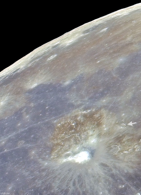
Telescopic mosaic from Earth at full Moon, stretched for color contrast, shows some of the wide variety of basalt in north Procellarum, and just how Krieger (arrow) overpowered by its young neighbor, bright Copernican age Aristarchus and its excavation of Aristarchus plateau.
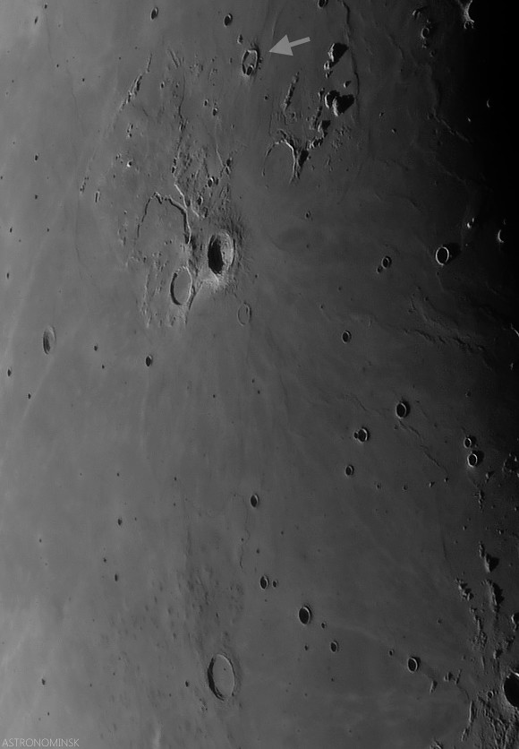
Local evening view de-emphasizes albedo and emphasizes terrain relief in this telescopic look at a 630 km field of view from Krieger (arrow, north) and Marius. (note the Marius Hills as their low profiles come into view on their namesake's north-northwest. Even the long Marius sinuous rille can be seen winding through the plain just north of those Hills. Krieger's morphology is still dominated by Aristarchus. Late crescent Moon mosaic by Astronominsk, September 25, 2008.
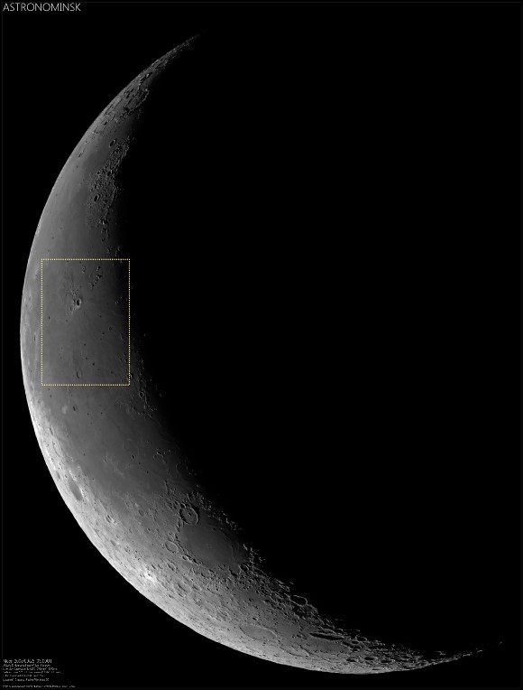
Very reduced view of the full-size ASTRONOMINSK late crescent Moon mosaic of 22 images, showing the field of view immediately above in context (inset). Note the differing perspectives on the Aristarchus Plateau, seen from Earth under a high and low Sun due to libration. The full mosaic can be viewed at the ASTRONOMINSK website, HERE.
To the east of Rima Krieger, we cross the contact between Oceanus Procellarum and Mare Imbrium (passing many kipukas along the way) and run northeast into the Gruithuisen Domes. To the south, the Rimae Prinze Region displays its many sinuous rilles, flooded craters, and massifs. To explore the entire region in more detail, check it out through the LROC QuickMap, HERE.

Related Posts:

Friday, April 6, 2012

LROC: The Rays of Messier A

The surface of Mare Fecunditatis, west of Messier A, peppered with hundreds of small craters. Image field of view is around 620 meters,  LROC Narrow Angle Camera (NAC) frame M159650657L, orbit 8661, May 10, 2011; incidence angle = 45.26° resolution 47 centimeters per pixel, from 40 kilometers altitude [NASA/GSFC/Arizona State University].
James Ashley
LROC News System

If you have ever studied the Moon through a backyard telescope, you may have noticed the Messier impact feature in Mare Fecunditatis (Sea of Fertility) beginning around day 5 of the lunar cycle. The distinctive appearance of the ray structure is particularly eye-catching. The high-reflectance of the main ray pair contrasts nicely with the lower reflectance background of Mare Fecunditatis. What would these rays look like close up? The LROC Narrow Angle Camera allows us to "zoom in" and find out as the subject of today's Featured Image.

When scanning the full NAC frame (see link again at the bottom of this post), we can readily detect the location of the prominent ray pair. Not surprisingly, we see many small, relatively recent craters when examining the scene more closely. At first glance it may seem that the bright rays are due entirely to these small craters, many of which excavated immature mare material (high-reflectance) from beneath the space-weathered surface layer of regolith.

A wider view shows the field of view in the LROC Featured Image (April 5, 2012) (white square) represents a much larger region of similar impacts. Field of view here is ~2.5 km. View the full-sized LROC context image HERE [NASA/GSFC/Arizona State University].
It would be tempting, then, to conclude that these small craters are all associated with the Messier A impact event. However, this determination is not straightforward. While some of these craters may be the result of Messier ejecta, there are also a great many similarly small, recent craters which clearly lie beyond the rays across the mare plains. It is possible that our eyes are deceived by the high-reflectance materials emplaced during the Messier impact event; note how the background reflectance between craters within the rays appears brighter than the reflectance outside of the rays. 

Elsewhere in the same NAC frame, a few kilometers to the north, the wide distribution of small boulders in the area of the bright rays trailing westward from Messier A, are, in a few spots, punctuated by 'house-sized' examples, deposited or present and clearly 'disturbed' by the force of perhaps three crater-forming Copernican Age impacts [NASA/GSFC/Arizona State University].
Because of the prevalence of random small impacts across the mare, it is difficult to determine which craters in this image are primary impacts and which are true secondaries associated with the Messier A impact. The impacting body that created Messier A excavated rock from the impact site (the vast majority of which was target rock, not the impacting meteoroid). The larger fragments may have been capable of creating recognizable craters. Distinguishing secondary from primary impacts can be a serious challenge for researchers who count craters to determine surface ages.

The Featured Image field of view is embedded within Messier A's unusual ray structure, something that becomes increasingly clear as the distance and perspective widens, in this LROC Wide Angle Camera mosaic and the images which follow. Field of view is 50 km across. [NASA/GSFC/Arizona State University].
Messier A, and a unique and newly simulated perspective from 26 kilometers over Fecunditatis, east by northeast of the familiar double crater (LROC WAC mosaics over LOLA laser altimeter-based topography). The landmark bright rays are directly opposite from how they are seen from Earth. The yellow arrow again shows the location of the field of view seen in the Featured Image. Though the Messier A progenitors' angle of attack was  highly oblique, the twin impacts also appear not to have been simultaneous. The rays continue beyond the western edge of Fecunditatis, 150 to 200 kilometers away [NASA/GSFC/LOLA/LMMP/Arizona State University].
Take a close look at the full NAC frame HERE to see more clearly where the ray begins and ends on this mare surface. You can find the Messier area in a small telescope by looking in Mare Fecunditatis beginning around day 5 of the waxing crescent Moon with each new lunar cycle. The walls of Messier A crater, with further discussion of the Messier crater complex, are showcased in Layering in Messier A. Other posts showing examples of secondary craters can be found in Regolith on Basalt, and Chain of Secondaries on Mare Orientale.

The face of Mare Fecunditatis and the bright rays trailing west from Messier and Messier as seen from Earth, in an extraordinary April 2009 mosaic imaged, layered and stitched by Astronominsk in Belarus. View the original HERE [Astonominsk].


Messier and Messier A  inspire a variety of theories about their origin, each suggesting an oblique impact, but like John Moore, we don't mean to suggest the single theory mentioned further above (that a group of moderately separated asteroids or comets past their Roche threshold, still sharing the same orbital plain, rendezvoused violently with Mare Fecunditatis in a cluster of three impacts) be thought of as definitive.

We added this video because it's, well... awesome!

Thursday, October 6, 2011

An ill-defined portion of an otherwise circular rim

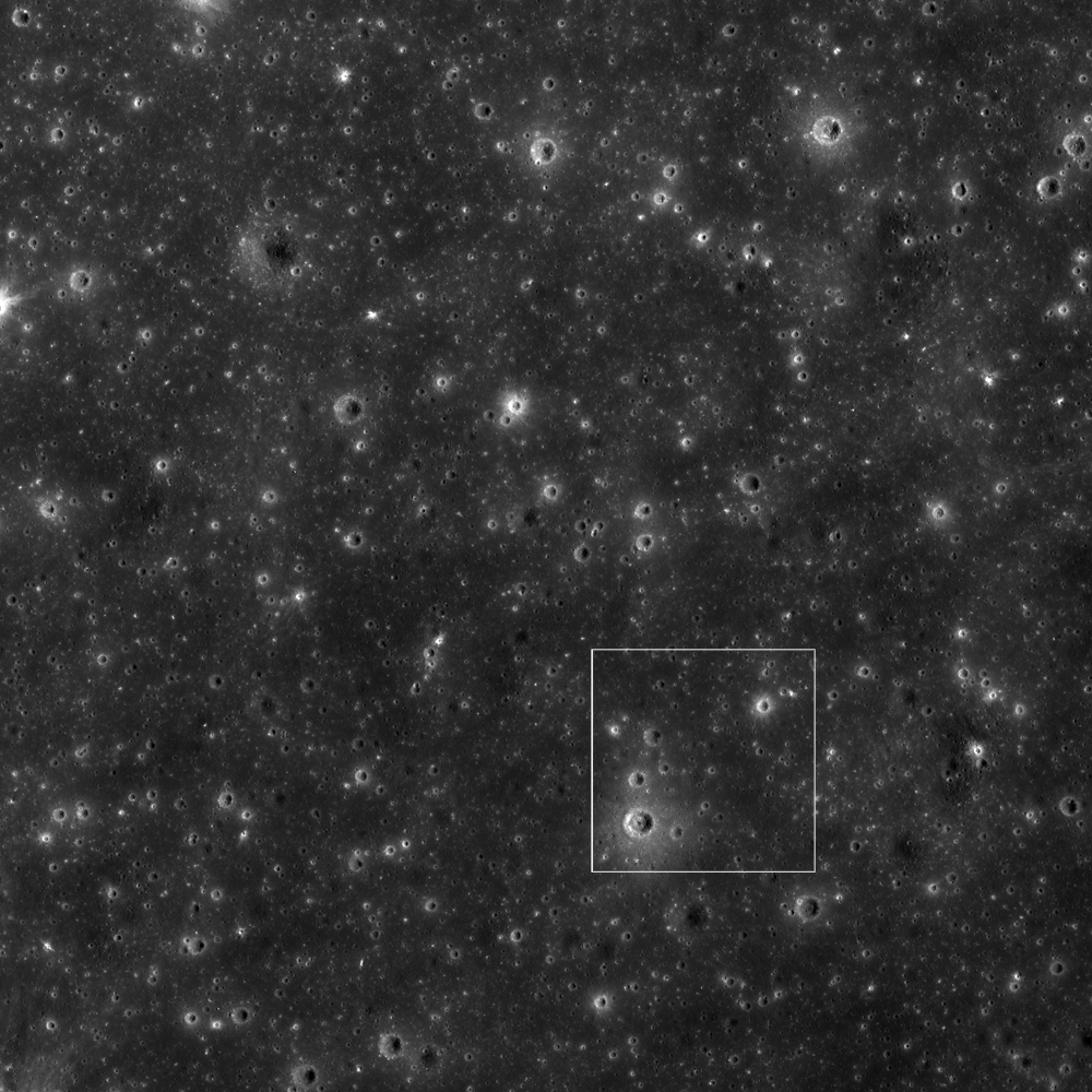
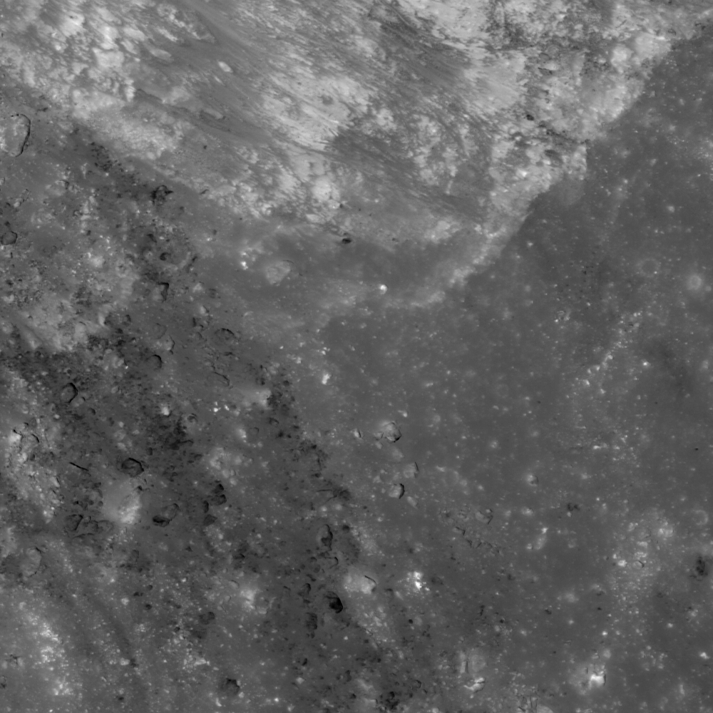
The bright craterlet rim of Nearside landmark Censorinus (upper right) is abruptly truncated by a pile of debris (lower left). LROC Narrow Angle Camera (NAC) observation M139694087R, LRO orbit 5720. September 21, 2010 (north is up), incidence angle is 9.32° and the field of view is 296 meter. See the full size LROC Featured Image HERE [NASA/GSFC/Arizona State University].
James Ashley
LROC News System

Censorinus is a fresh impact crater along the southeastern shore of Mare Tranquillitatis (0.47°S, 32.73°E). The amount of detail in the NAC frame is staggering, and worthy of a baker's dozen Featured Images. Noteworthy, however, is how well-formed and highly circular the rim is with the exception of this small portion along the southeast perimeter. Are there good geologic reasons for something like this, or is it simply the luck of the draw which portion of a crater rim will get a little sloppy? Such things are not much more than curiosities, but they are great for initiating geologic discussion!


The full-width of the featured NAC frame shows context of the Featured Image above (white rectangle) and the circularity that persists along most of the eastern Censorinus rim. LROC NAC M169398317R, field of view ~2.4 km (north is up). View the higher-resolution original LROC context image accompanying the Featured Image release HERE [NASA/GSFC/Arizona State University].
A neat, circular crater is usually a sign of sufficiently high energy from a hypervelocity projectile to create an explosive outcome. Censorinus is clearly the result of just such a high-energy, explosive event. In the case of the featured area of the rim, however, we see that energies were not high enough to excavate the target material radially all the way to meet the rest of the rim, but stopped short, as though making a smaller-diameter feature. This action resulted in littering the surface adjacent outside the wall with loose ejecta blocks, giving the impression that the rim stops suddenly in the Featured Image.

Censorinus (left) and Censorinus A (right) in a single band (566 nm) color LROC Wide Angle Camera (WAC) mosaic swept up during two orbital passes over this area, on the south frontier of Mare Tranquillitatis June 7, 2011, about 40 hours after local sunrise, when the Moon was barely more than 6 days old. At this scale the discontinuity of the south-southeastern rim of Censorinus is easy to see, perhaps the result of slumping of material from adjacent high ground in that direction [NASA/GSFC/Arizona State University]/
Why was material in this portion not accelerated to create a neat rim? Since the 'ground zero' target rock was destroyed in the impact, it is difficult to tell what kind of influence the local geology may have had on the energy distribution. The final answer therefore remains a bit of a mystery, but it is probably safe to speculate that target lithologies played a role here. The terrain along this portion of Mare Tranquillitatis shoreline is fairly rugged, and may contain a variety of rock types, some of which may be more resistant to excavation than others, thus creating a heterogeneous target for an incoming bolide!. A partially buried block of hard rock or even greater-than-average compaction in the regolith might be all that is needed to explain today's Featured Image.

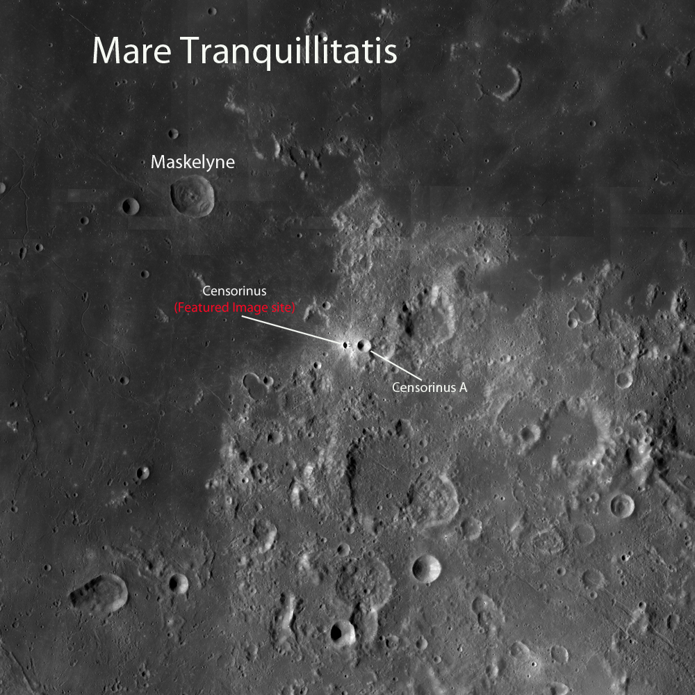
This WAC mosaic context image shows the location of Censorinus and Censorinus A in relation to Mare Tranquillitatis, two relatively fresh craters. Though Censorinus A is larger than Censorinus, the latter is probably younger and thus more reflective and less "gardened" by impacts into darker "optical maturity." Censorinus was identified in early telescopes and Moon maps much sooner.Image field of view is roughly 360 km in height. See the higher-resolution LROC context image HERE [NASA/GSFC/Arizona State University].
A highly reduced "thumbnail" version of a much larger black and white mosaic assembled from several digital stills by Yuri Goriachko of Astronominsk in Belarus. Because the landmark Nearside equatorial crater stands out so well from the background, despite its small size, it almost seems unnecessary to mark bright Censorinus with a yellow arrow [Astronominsk].
The high-reflectance spot that marks the location of the Censorinus - Censorinus A crater pair may just be visible through a small telescope at the southwest edge of Mare Tranquillitatis beginning about the First Quarter phase of the lunar cycle, but albedo differences will become more accentuated as the Moon waxes to full and the shadows shorten.

What additional clues can you find in the full NAC frame

Other examples of asymmetry in impact features can be found in the distribution of rubble on the floor of this crater, and the distribution of impact melt around this crater.

Saturday, July 24, 2010

The colorful Moon


Following up on Dr. Mark Robinson's LROC Featured Image, "Aristarchus - Up from the Depths," from July 20 presented the opportunity to add some color to create a value-added product. Above, at its heart, is a new three-dimensional glimpse north from high over the southern rim of the dazzling and brilliant Copernican-age crater Aristarchus, possible by superposition of LROC Narrow-Angle Camera (NAC) observation M122523410 onto a low-resolution digital elevation model of Aristarchus Plateau available through the Google Earth application. A touch of color has been added, previously available only to the most diligent operators of telescopes, Clementine data and, most recently, LRO's fast-developing Wide Angle Camera catalog. The ultimate potential of such recombinations boggle the mind.


From 2008, a 200 kilometer-wide (at bottom) SELENE-1 (Kaguya) HDTV view of Aristarchus Plateau, very close to it's true optical appearance from orbit. Subtleties of actual color variation are difficult to detect, though they are definitely present [JAXA/NHK/SELENE].


Aristarchus (July 25, 2008, 02:33UT) composed by "The Boys from Minsk," aka Astronominsk (Goryachko, Abgarian & Morozov), who were not the first to demonstrate the availability of color in lunar photography, even from 400,000 km away. This image of Aristarchus was featured by Charles Wood as Lunar Picture of the Day (LPOD), August 5, 2008. [Maksutov-Cassegrain Santel (D=230mm, F=3000mm), barlow 2x, CCD mono camera Unibrain-702 (1388x1040), Astronomik RGB TYP II filters. "Seeing" = 6/10, Trans 5/5].