Showing posts with label Archimedes. Show all posts

Thursday, February 7, 2013

Archimedes Rock Garden

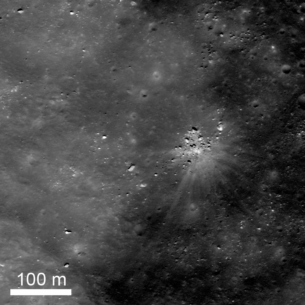
A group of rocks, a small shallow crater, and rays of ejecta occur together up on one of the fault terraces of the crater nearside landmark crater Archimedes. Cropped from LROC Featured Image released February 7. 2012 - LRO Narrow Angle Camera (NAC) M109256375R, spacecraft orbit 1235, October 4, 2009; resolution 52 cm per pixel, 31.95° angle of incidence, from 52.35 km [NASA/GSFC/Arizona State University].
Jeffrey Plescia
LROC News System

A collection of rocks up to about 8 m across surround a small shallow crater, also about 8 m in diameter. A series of bright ejecta rays surround the area. The site lies on the edge of one of the northeast faulted terraces of Archimedes crater (83 km) at 30.154°N, 357.141°E.

Understanding the origin of this distinctive scene is not necessarily straight forward. At the center is a shallow crater about 8 m in diameter, and a series of bright rays extend away from the crater out to distances of about 150 m. Note that some of the blocks seem to block the rays. On the southwest side there is a large rock about 6 m across, bright lanes of ejecta extend past it on both sides but not behind the rock. To the north, a collection of rocks forms a semicircle; within that semicircle is bright ejecta, but not much beyond.
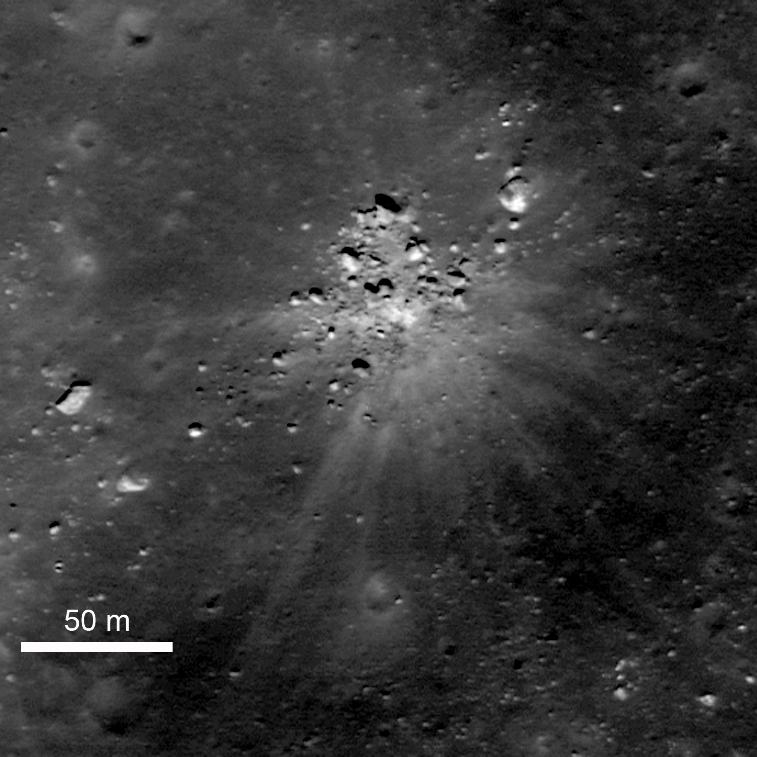
Zoomed in view of the area shown in the Featured Image. The rocks immediately around the impact site are on the surface. The large bright rock to the northeast and several of those to the southwest are buried by older regolith. LRO NAC M109256375R [NASA/GSFC/Arizona State University].
Not all of the rocks in the scene are related to this event. To the northeast there is a bright, partly buried rock about 12 m across, and the west-southwest an elongate rock 7 x 14 m rests of the surface.

The question is, what happened?

One possibility is that there was already a collection of rocks on the surface and a small meteor happened to hit in a small open area among them; then as the ejecta spread out, it was blocked by the rocks.

Another possibility is that there was a giant boulder at this location that just happened to get hit by a small meteor, shattering the boulder into the pieces that now surround the crater.

The third possibility is that a large boulder ejected during the impact of Archimedes (or from some other nearby impact) landed here and shattered upon impact making a small crater. If the boulder was from the Archimedes impact, it must have been launched into a high trajectory such that it hit the surface only after most the impact activity had ended.

An earlier LROC NAC survey of the terraces and northeast floor of Archimedes. The 'rock garden' is designated with the yellow arrow. A 1.29 meter resolution frame considerably resampled to view the full-width of a 6.46 km-wide field of view. LROC NAC M106898464R, orbit 894, September 6, 2009; 39.9° angle of incidence, from 160 km [NASA/GSFC/Arizona State University].
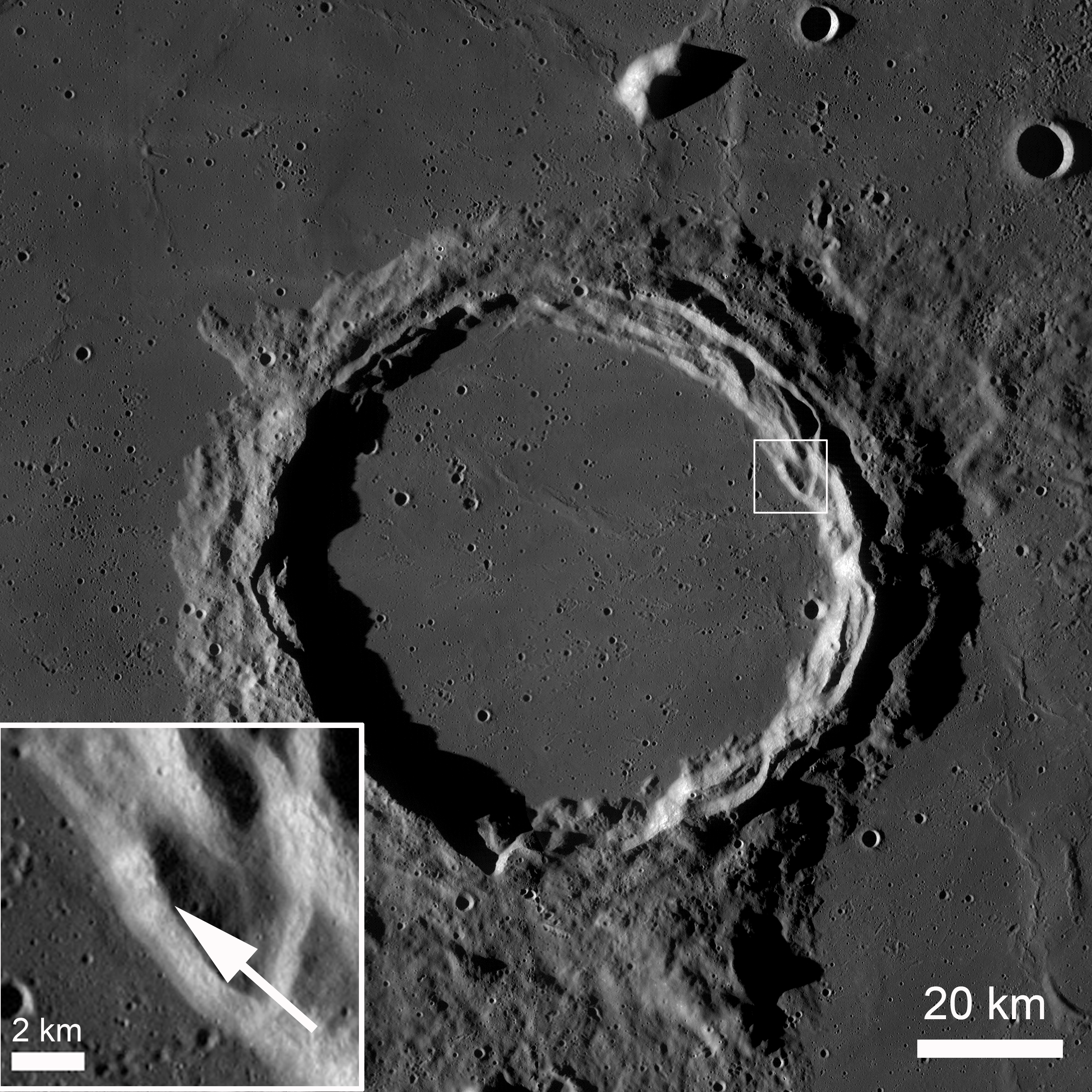
Archimedes under afternoon illumination. The small box on the northeast edge of the terraces in shown as an enlarged inset in the lower left, denoting the location of the rock garden and adding some context also to the image immediately preceding this one. LRO Wide Angle Camera (WAC) mosaic. [NASA/GSFC/Arizona State University].
The area of the rock garden lies on the edge of the Archimedes terraces.  Archimedes is 83 km diameter and lies on the eastern edge of Mare Imbrium.  It is filled with and surrounded by mare basalts on most sides. The crater floor lies a couple hundred meters below the surrounding mare.

Explore more of Archimedes in the full LROC NAC, HERE.

Related Posts:
Archimedes - Mare Flooded Crater!
Sunset Over Giordano Bruno
Necho's Terraces

Archimedes as viewed from the northest, high over Mare Imbrium through the HDTV camera of Japan's SELENE-1 (Kaguya). Further south are the Montes Archimedes and on the left, at the foot of the Appenines (arcing south beyond the horizon), is Palus Putredinus and Hadley Rille, landing site of Apollo 15 in 1971 [JAXA/NHK/SELENE].

Thursday, March 3, 2011

LROC: Mare Flooded Archimedes


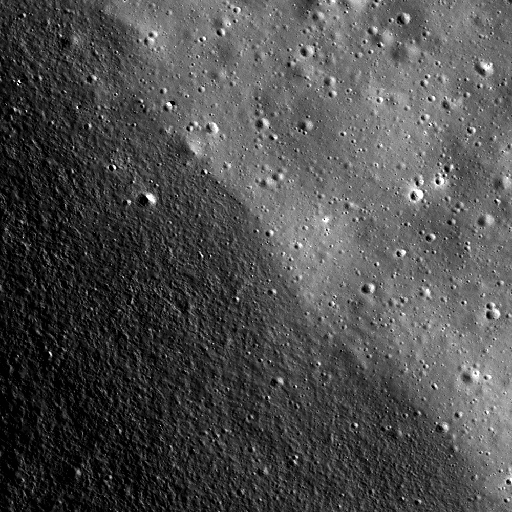
Contact between Archimedes' southwestern interior crater wall (lower left) and floor (upper right). The floor is smooth and relatively flat, compared to the sloped and rough elephant skin-textured crater wall. LROC Narrow Angle Camera (NAC) observation M119883761, LRO orbit 2801 (alt. 39.33 km, res. 0.62 meters per pixel) field of view 800 meters. View the full-sized Featured Image HERE [NASA/GSFC/Arizona State University].

Drew Enns
LROC News System

Archimedes is an 83 km diameter crater located in east Imbrium basin (29.7°N, 356.0°E). Archimedes is notable for its smooth floor, but unlike other craters (e.g., Necho & Copernicus) with smooth floors, Archimedes is flooded with mare basalt. Craters with flooded floors are geologically important as they can establish relative ages of features thanks to the geologic law of superposition.


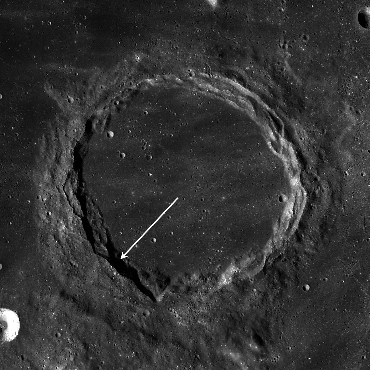
LROC Wide Angle Camera monochrome mosaic, context image showing Archimedes. The 85 km-wide crater floor appears as smooth as Mare Imbrium to the northwest. Arrow shows location of the LROC NAC Featured Image. Field of view is 130 kilometers, view the full-sized context mosaic HERE [NASA/GSFC/Arizona State University].


A second LROC WAC monochrome (689nm) mosaic swept up over several orbital opportunities on January 7, 2010, at local afternoon. View a 800 pixel-wide version of the above mosaic HERE [NASA/GSFC/Arizona State University].

Because both Archimedes and Imbrium basin are flooded by mare basalt, their formations must be older than the volcanic activity. Furthermore, because Archimedes is located within Imbrium basin, Archimedes must be younger than Imbrium. Just by studying relationships between features, scientists can piece together their history!

Explore more of Archimedes' floor in the NAC frame!


Archimedes from the northwest, high over Mare Imbrium and in HDTV from Japan's SELENE-1 (Kaguya). Further south are, appropriately enough, the Montes Archimedes and further left, at the foot of the Appenines marching beyond the horizon, is Palus Putredinus site of Hadley Rille and the 1971 Apollo 15 expedition. View a larger image HERE [JAXA/NHK/SELENE].

Related Posts:
Central Peak/Mare Boundary
Aitken Crater Constellation Region of Interest

Tuesday, October 12, 2010

LROC WAC: Archimedes


From LROC Wide Angle Camera monochrome (689nm) mosaic of tell-tale Archimedes region, hugging the southeastern edge of the Imbrium impact basin. Even evidence for "emplacement" set forth in studies of 85 km-wide Archimedes (29.7°N, 356°E) was not enough for some early Space Age investigators to accept. Nevertheless, evidence mounted and the sequence generally went something like this: Imbrium impact, Archimedes impact affecting areas in the immediate vicinity, and then the Mare Imbrium mare basalt melt seen today, and embayment of lower elevations [NASA/GSFC/Arizona State University].